B20
| B20 | |
|---|---|
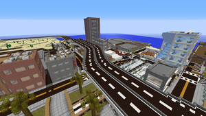
 The B20 through Farwater | |
 B20 shield | |
| Alternative names | Farwater Skyway Desert Shore Highway |
| Direction | East-West |
| Route | |
| At-grade intersections | 2 |
| Standard exits | 4 |
| Partial exits | 3 |
| Interchanges | 1 |
| Western terminus | East City Interchange, Solarion |
| Eastern terminus | Santa Monica Blvd and Venice Ave, Los Angeles |
| Status | Open |
| Contractors | |
| Planners | diemundz allifarki |
| Builders | diemundz allifarki TrainPro TheMiner_ _Kastle jphgolf4321 kekkomatic |
| Owners | diemundz allifarki |
The B20, also known as the Farwater Skyway and the Desert Shore Highway, is a major east-west B-class road that serves the far eastern part of the server in Ward 2 of the New World.
Route
The B20 is a high-capacity road and is at least four lanes wide, with two lanes in each direction, for the entire length of its original route. The road has a lower speed limit than other B-class roads, as much of the road is in urban areas, and the segments built at ground level in the desert traverse terrain that is difficult to negotiate at high speeds.
Solarion
The road begins in Solarion and heads north toward Ellesume before making a right turn and entering a tunnel into Ellesume.
Ellesume
After the tunnel, the road meets with Ellesume's main freeway, LH-1 before then making a turn right to head south then turning eastbound into the Ashton Mall area. Afterward, the road begins heading southbound out of the town before making a curve eastward towards Farwater. In June 2016, this section of the road was updated to controlled-access freeway standards, which involved submerging the freeway into the ground, adding a median and barriers, and the construction of exit ramps to connect the freeway to the existing road system.
Eastern Desert
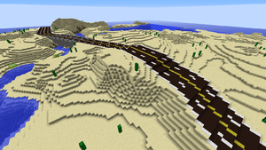
Being a B-class road, most of the road remains level with the terrain throughout the desert. However, the road follows a winding river, crossing it a total of five times over four bridges, and it also has a long tunnel underneath a large sand dune to the west of Farwater. Approaching Farwater to the west, the road splits into two carriageways and once again becomes a controlled-access elevated freeway, similar to A class roads.
Farwater
When entering Farwater's Westside neighborhood, the road is renamed to the Farwater Skyway. The first exit in Farwater is a one-way offramp in which drivers can turn onto southbound B220 (Altos Street). The road continues south through Farwater's downtown area before intersecting with B220 again in a three-way interchange. The highway then continues south towards Farwater's Beverly's Hill neighborhood towards Los Angeles.
Los Angeles
B20 becomes a two-lane road after entering the Los Angeles city limits, continuing along a city street until it reaches its eastern terminus at Santa Monica Blvd and Venice Ave.
History
Planning
The B20 was originally known as B35 and was planned by allifarki to go from Ellesume south to Airchester. It was decided that the road should go to Farwater instead, utilizing the then intra-city expressway system to continue the route through the city.
Phase 1
diemundz, the mayor of Farwater, took charge of building the road through Farwater, and it was given its new number to reflect the fact that most of the road would be located in Ward 2 instead of Ward 3. While the B20 was still under construction, its auxillary loop, B220, was built to serve the expanding Westside neighborhood of Farwater. The first phase of the road between Ellesume and Farwater was finally completed on January 4, 2016.
Phase 2
Though the B20 was originally planned on being extended south towards Airchester, these plans were scrapped in favor of having a differently numbered highway planned instead, with an odd number to designate it as a primarily north-south route. However, when Los Angeles was built directly south of Farwater, these plans were scrapped yet again in favor of extending the B20 south through Beverly's Hill to the newly-constructed city. The extension was completed on May 14, 2016.
Exit list
This list is non-comprehensive.
Key:
- Interchange exit
- Standard exit
- Rest area exit
| Status | Exit number | Destinations | Road designation | Notes |
|---|---|---|---|---|
| 1 | Los Angeles |
|||
| 2 | Beverly's Hill Boulevard, Beverly's Hill |
|||
| 3 | Figtree Street, Downtown Farwater |
|||
| 4 | Cucumber Street, Westside Farwater | |||
| 5 | Easy Street, Westside Farwater | |||
| 5 | Altos Street, Westside Farwater | |||
| 6 | Waterside Interchange ( A21 - If Accepted) (closed) |
|||
| 6 | Waterside Services (closed) | |||
| 7 | Ellesume - Ashton Mall Site (under construction) |
|||
| 8 | Ellesume - Desert Shore Street |
|||
| 9 | Ellesume - City Expressway |
|||
| 10 | Ellesume - Paris Island |
|||
| 11 | Solarion - City Freeway J1 (planned) |
