B209
 | |
|---|---|
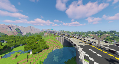
 The B209 near the Cresta Customs and Border Checkpoint. | |
| Information | |
| Planner | kyyl_ |
| Builders | kyyl, Crafterboi500 |
| Number of Exits | 3 |
| Terminus North | Encinitas |
| Terminus South | Solana Beach |
| Status | |
| Encinitas | |
| Solana Beach | |
| San Diego | |
The B209, also known as the B209 - San Diego Freeway, is a B-class controlled-access highway that links the cities of Encinitas, Solana Beach, and San Diego. It is a project of the Metropolitan North Association's RoadNorth. The B209 was approved at the Infrastructure Staff Meeting of November 2020 and the first portion between Encinitas and Solana Beach was finished before the December 2020 General Staff Meeting. Within Cresta, it bears the CR1 shield.
Route
The freeway starts at the City Precinct of Encinitas, and then continues south towards the Loma Sur Mountain Range. It then tunnels under the mountains, out of Cresta, then continues southwest towards Solana Beach. The segment between Encinitas and Solana Beach was built by kyyl_ and is completely open. The segment between Solana Beach and San Diego is currently planned.
Exits
| Status | Exit number | Destinations | Road designation | Notes |
|---|---|---|---|---|
| Inside Cresta Borders Inside Encinitas City Limits | ||||
| 0 | Encinitas - Escondido Street |
Northern terminus. | ||
| 1 | Encinitas - Joya Street |
Exit to Joya Airfield and Cresta Capitol. | ||
| 2 | Encinitas - Seashell Way (planned) |
|||
| Outside Encinitas City Limits | ||||
| 3 | CR2 Cabo de la Luna (planned) |
CR2 Cabo Highway | ||
| Outside Cresta Borders Inside Sedalia Borders | ||||
| 4 | VR-43 Bridgewater (planned) |
VR-43 Birch Highway | ||
| Inside Bayport City Limits | ||||
| 5 | Bayport - Marion Way | |||
| 6 | Bayport - Downtown (planned) | |||
| Outside Bayport City Limits | ||||
| 7 | Alana (planned) | |||