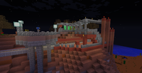
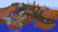
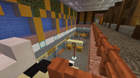
Birdhall Metro
The Birdhall Metro is an intracity rail system operating in Birdhall, created by Robang592 on 16 October 2015.
History
Back To Square One (Before Oct '14)
Robang's previous transit system, the Chack City Subway, was not much of a feat, but he decided to base the metro off that anyway. As such, the lines were originally named after different wood types (eg: Acacia Line, Oak Line, etc). This was scrapped later because of the lack of types of wood at the time.
The metro was already obligatory when Birdhall was starting out. However, due to certain misconceptions about the ranking system, the metro wasn't built until Robang met [Councillor] rank. Before [Councillor], exits were pre-built at their present locations, albeit with minor differences, such as how T3 S1 W1 Robin's exit was supposed to be on the opposite side of the road.
The moment the rank was given on 16 October, Robang immediately began construction on the first station, D1 T2 Birdhall.
Progress Is Made (Oct '14 - Jan '15)
The first line to be established was the District Line . The first 3 stations on it opened 2 days after construction began. A new line, the District Spur , which would later become the Southhall Line , was built on 21 October. This spur line would have facilitated the projected southerly expansion to the city. On the 22nd, with the completion of both the Downtown Line and D2 T4 ChackHall, the full planned system for the small but growing city was built -- 5 stations, 2 lines. The headquarters was built shortly after, on the 30th, at Robin Road.
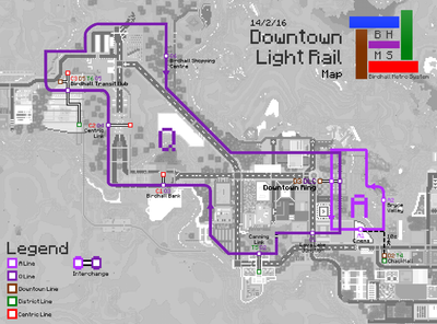
In November, the Downtown Light Rail was created with the A Line being first to open. Initially, the system would have consisted four branches in an 'X' formation. They were named A , Q , V and W , and would connect to both D3 Downtown Ring and D4 Downtown Boulevard. These line names were chosen to deconflict with any other abbreviations (notably " D ", which would be already taken by the Downtown Line ). The 4 branches were planned to serve a much larger downtown area. The A and Q Lines would have covered the south-east and south-west of the estate, whilst the V and W Lines would cover the north-east and north-west. When the final plan for the downtown area was established, the W Line merged with the Q Line and the V Line was removed entirely.
A depot was built on the 13th, storing rolling stock for the two lines. The Downtown Line was now growing fast, reaching up to D4 Downtown Boulevard, as well as the District Line and Q Line , which were both now up to T5 DQ2 Canning Link.
The Centric Line's Failure (Feb - March '15)
Birdhall would have seen an extension going north back in 2015. Known now as the Centric District, it was going to be a bustling extension to the Downtown Estate, complete with its own visitor centre. Unfortunately, another player soon claimed the area north of Birdhall which prevented any further extensions north of the transit hub area and halted several plans. One of these was the Centric Line . Originally intended to serve the entire Centric District, the line was actually going to be very long, spanning more than the current four stops. In fact C4 Spurnton Point was never in the original plans. It was only after the player's claim that the line was detoured to a newer extension of the city to the west. It was a giant hiccup, and the line is now a short stub coming out of the light rail tracks.
The Transit Hub (Apr - June '15)
After the flop that was the Centric Line , Robang knew the next thing that was coming up needed to be huge and successful. So, the Birdhall Transit Hub was created. It is built in a very nice natural valley in the mesa which was only modified very minorly during construction. All lines but the Southhall Line and Wrenough Line connect to the hub. The hub also serves as the linkpoint for intercity rail services such as IntraRail.
The Southhall Line (Dec '15 - Apr '16)
Nothing really happened for a few months, since all plans were, again, completed. Then, suddenly, the new Southhall Districts were created. The plan was to extend the previously dormant District Spur to the south. However, due to possible confusion dealing with two lines sharing the same colour, a new line was created: the Southhall Line , which took over the one station spur line. In both T3 S1 W1 Robin and S2 W2 Southern Forest, there are still places that retain the original colour of the District Spur . In the coming months, three more stations were built on the south plateau of Birdhall. Of these, two above-ground stations were built with experimental track designs, each with a very narrow stature. Only 2 months later, the Southhall Line was completed.
The Power of The Internet (June '16)
In early January 2016, Robang posted a new video to his channel where he showcased the Birdhall Metro at the time. It quickly gained views in the hundreds, now being one of the top videos on his channel, with over 30K views. Soon enough, people started suggesting new lines and joined the server. One of these comments posted on 14 June 2016, prompted Robang to start a new line that would serve further south of Birdhall, reaching the city limits. It became the newest line on the network, the Wrenough Line . Although not verbatim to the suggestion, it still shows how the internet can bring things to life and influence others.
Onward to the Future (Present)
With little development to Birdhall in 2017, not much occurred. The Wrenough Line had, at this time, made it all the way to W6 East Cliff Park and a new station in the Sandstred Estate, named W7 Farfetch'd Street. The Sandstred Light Rail began service in mid-2022 and accompanies the road network of the area, cutting across paths and junctions in a "open transit network" style.
From 13 December 2023, the Centric Line and District Line transitioned to using TrainCarts as a test to evaluate the feasibility of implementing it throughout the entire network.
Mass Rail Lines
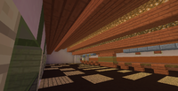
The metro has 5 mass rail lines. Typically, mass rail lines have gantries and larger, longer platforms than light rail lines.
They mostly have very basic call-cart systems. The Centric Line and District Line currently operate using TrainCarts that will be destroyed once they reach the end of the line. Otherwise, players must remove their carts when disembarking as there is no cart return mechanism.
Downtown Line
![]() Good service: Train lines are running smoothly.
Good service: Train lines are running smoothly.
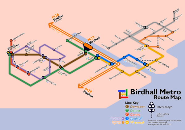
The Downtown Line serves the more urban areas of Birdhall, eponymously named. It generally stretches to a north-westerly direction. It is coloured brown - a reference to the original colour of the Singapore MRT's Downtown Line - and has 5 stations.
District Line
![]() Good service: Train lines are running smoothly.
Good service: Train lines are running smoothly.
The District Line goes through various districts throughout Birdhall. It is coloured green - a reference to the London Underground's District Line - and has 6 stations.
Centric Line
![]() Good service: Train lines are running smoothly.
Good service: Train lines are running smoothly.
This line travels around the Centric District of Birdhall. While this line was meant to be longer, the halting to the northward expansion of Birdhall meant this line got truncated and rerouted to Spurnton instead. It is coloured red, and has 4 stations.
| Status | Code | Station name | Connections |
|---|---|---|---|
| C1 DQ3 | Birdhall Bank | DTLR Q Line | |
| C2 DQ4 | Centric Link | DTLR Q Line | |
| C3 DQ5 D5 T6 | Birdhall Transit Hub | Downtown DTLR Q Line District | |
| C4 | Spurnton Point | No connections |
Southhall Line
![]() Good service: Train lines are running smoothly.
Good service: Train lines are running smoothly.
This line serves the southern portion of Birdhall and replaces the District Spur . This line can bring you to Birdhall's current landmark, the Birdhall Amphitheatre. It is coloured blue and has 5 stations.
| Status | Code | Station name | Connections |
|---|---|---|---|
| S1 T3 W1 | Robin | District Wrenough | |
| S2 W2 | Southern Forest | Wrenough | |
| S3 | Plateau Street | Birdhall Amphitheater | |
| S4 | Newbin | No connections | |
| S5 W5 | Portside | Wrenough |
Wrenough Line
This line goes through the south-western portion of Birdhall, reaching the city limits. The name "Wrenough" is a portmanteau of the words "Wren" (a species of bird) and "Borough". This line is coloured orange-yellow/gold and has 6 confirmed stations, with an extension to the southeasternmost parts of Birdhall in the works. It has code W .
Light Rail Lines
Light rail lines are lower capacity lines aimed as feeder services for specific areas. They do not usually have gantries, and both tracks and stations are smaller in size and complexity. Additionally stations are laid closer together to facilitate passenger collection. They are thinner-stroked on maps.
Downtown Light Rail
A Line ![]() Good service: Train lines are running smoothly.
Good service: Train lines are running smoothly.
Q Line ![]() Good service: Train lines are running smoothly.
Good service: Train lines are running smoothly.
The Downtown Light Rail consists of 2 unidirectional loops, the A and Q lines, that go around the downtown district of Birdhall. It was very loosely based off the Hong Kong MTR Light Rail. These two lines join at the Downtown Light Rail Central Station at D3 DLC Downtown Ring. The only underground light rail station, DQ1 Lava Lake Junction, is on the Q Line .
A Line
| Status | Code | Station name | Connections |
|---|---|---|---|
| DLC D3 | Downtown Ring | Downtown | |
| DA1 | Cinema | No connnections | |
| DA2 | Bryce Valley | No connnections |
Q Line
Sandstred Light Rail
![]() Partially open: In early development.
Partially open: In early development.
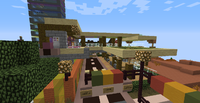
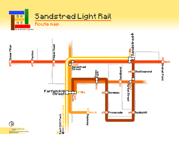
The Sandstred Light rail system is an above-ground network of low-capacity lines that serves the currently developing Sandstred Estate to the east of Southhall. It is much like the Downtown Light Rail in that it consists of a few split branches of lines that loop and intersect at two central stations. Designed in an "open network" style, the tracks cut across paths and roads, accompanying the network of transport in the general area. The line is coloured orange and has code N .
Station codes follow the rule N (cardinal direction) (station number) , where the cardinal direction is the first letter of the branch in lowercase. The north, south, east and west branches are coloured on signs as red, yellow, green and blue respectively for easier comprehension. The central stations, W7 Farfetch'd Street and W8 Sandstred, have their directions labelled a and b respectively and the number removed.
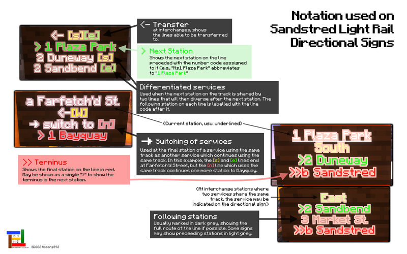
The four lines may be thought of as services rather than individual lines, as they may use the same line of track simultaneously. For example, at W7 Na Farfetch'd Street, the North , South and East Branches all use the same northbound track at platform D. While the South Branch and East Branch services terminate here, the North Branch continues using the track up to Nn1 Bayquay. Thus, carts on South or East Branch services that terminate at W7 Na Farfetch'd Street can continue on and switch to a North Branch service. Such switches are notated on the directional signage upon arrival at the station.
North Branch
| Status | Code | Station name | Connections |
|---|---|---|---|
| Nn1 | Bayquay | No connections | |
| Na W7 | Farfetch'd Street | Wrenough s e | |
| Nn2 Nw2 | Sandstred Circus (planned) | w |
South Branch
East Branch
West Branch
Signage and Notation
Line codes
Each line on the network has a single letter code assigned to it which may be used in signs. Usually, this is the first letter of the line's name. However, to avoid conflict with lines with the same initial, some exceptions to the rule exist. A triple-letter code also exists, but it is normally used for light rail lines.
| Line | One-Letter Code | Three-Letter Code | Other Code(s) | ||
|---|---|---|---|---|---|
| Downtown | [D] | DTL | |||
| District | [T] | - | |||
| District Spur * | - | - | [TS] | ||
| Centric | [C] | - | |||
| Southhall | [S] | - | |||
| Wrenough | [W] | WNL | |||
| Downtown Light Rail A Line | [A] | DLR | [DA] | DTLR | |
| Downtown Light Rail Q Line | [Q] | [DQ] | |||
| Sandstred Light Rail North Branch | [N] | [n] or (n) | SLR | [Nn] | |
| Sandstred Light Rail South Branch | [s] or (s) | [Ns] | |||
| Sandstred Light Rail East Branch | [e] or (e) | [Ne] | |||
| Sandstred Light Rail West Branch | [w] or (w) | [Nw] | |||
| Light Rail | LR | ||||
*The District Spur is a defunct line. The code used is kept here for posterity.
Station codes
Each station on the network is assigned a two- or three-character code for accessibility. The code is made of the line code followed by the ordinal number of the station on the line. For instance, Birdhall station is coded D1 T2 , being the first station on the Downtown Line and the second on the District Line . Exceptions include the Downtown Light Rail Central station at Downtown Ring, which has code DLC , and both central stations on the Sandstred Light Rail which have their ordinal numbers replaced by a and b.
Abbreviations
Due to sign space constraints, abbreviations to words and station names are used throughout the network. In administrative situations (such as on serial numbers) a station's name can be abbreviated to triplet codes as well. Some examples are detailed below.
| Station/Word | Abbreviation(s) |
|---|---|
| Birdhall | BDH, BH |
| North Cliff Park | NCP |
| East Cliff Park | ECP |
| Park | Pk. |
| Downtown | DT |
| Boulevard | Blvd. |
| Link | Lk. |
| Street | St. |
| Road | Rd. |
| Transit Hub | Trans. Hub, TH |
| Point | Pt. |
| Shopping Centre | SC |
| Junction | Junc., Jn. |
| Farfetch'd Street | F'fetch'd St. |
| Sandstred | S'tred |
| Northern/North | N. |
| Southern/South | S. |
| Eastern/East | E. |
| Western/West | W. |
| Loop | Lp. |
| Platform | Ptfm., Pltfm. |
| Station | Stn. |
Directional Signage
This section refers to signs that display the current, next and/or terminal station on the line as well as any other useful information.
Older System
On older lines, arrival signs included only the name of the current station, that of the next station, and any lines that may be transferred to. Newer mass rail lines may include a more concise version of these signs that use the shorthand shown below.
| Icon | Meaning |
|---|---|
| = | This station |
| -> | Next station |
| -| | Terminus |
| >-< | Change for... |
| >< | |
| X | No service |
Newer System
The Sandstred Light Rail trials a distinct system of directional signage that may be carried over to older lines. Notably, it makes use of formatted text (colour, underlines etc.). It is detailed in the image below.
