Chack City Subway
| Chack City Subway | |
|---|---|
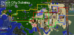
 A map of the subway | |
| Route | |
| Lines | C Town Hall to Uptown R CC Waterfront to CC North E Uptown to CC Waterfront G CC Waterfront to Police Station D Downtown to Greenhouse (Loop) U Uptown to Cactus Hill (Loop) |
| No. of stations | 30 |
| Key individuals | |
| Main builder | Robang592 |
| Additional builders | Kottlewing (D Line) |
The Chack City Subway is the subway system of Chack City founded and constructed by Robang592. The system currently has 30 stations and six lines.
The subway opened on October 11, 2013. The design of the stations is non-automated and uses the basic cart launcher.
History
Chack City was founded on February 1, 2013. The Chack City Subway was originally planned to consist of two lines, the Lapis and Coal Lines. The Coal Line first opened on October 11, 2013, with Town Hall Station, followed by City Gallery.
The second line, the Lapis Line, was supposed to go to western Chack City. It originally only had two stops and interchanged at City Gallery Station. This plan was then cancelled as there was not any development in that section of the city at the time of construction in 2013. Since then, the Lapis Line's route became the route of the Redstone Line.
In 2014, Chack City Airfield was built south of Chack City. A Coal Line spur was planned to be built to connect the airfield to the rest of Chack City; however, construction abruptly stopped as it was too close to Town Hall Station.
There was a plan to build another line named the Iron Line. The line would have been operated by Palelmo Transit; however, as the Palelmo Transit ceased operations, the Iron Line was cancelled.
Subway Lines
Subway lines are normal rail lines and are named after different ore blocks (eg. Coal, Redstone, etc.).
Coal Line (C)
The coal line goes from the South of Chack City to the South West of it. The stations go from C1 Town Hall to C5 Uptown. Completion: 11 October 2013
| Status | Code | Station name | Connections |
|---|---|---|---|
| C1 | Town Hall | No connections | |
| C2 | City Gallery | No connections | |
| C3 R4 E3 | Chack City Transit Hub | R E | |
| C4 R5 D1 | Downtown | R D | |
| C5 E1 | Uptown | E |
Redstone Line (R)
The Redstone Line goes from the West of Chack City to the East of it. The stations go from R1 Chack City Waterfront to R8 Chack City North. Completion: 19 March 2014
Emerald Line (E)
The Emerald Line goes from the East of Chack City to the South West of it. The stations go from E1 Uptown to E5 CC Waterfront. Completion: 25 April 2014
Gold Line (Jungle Line) (G)
The Gold Line is a line built in the Jungle Estate and its surroundings, going from G1 E4 R1 Chack City Waterfront to G6 Police Station. It may also be expanded to Chack City Transit Hub station. Completion: 14 June 2014
Shuttles
Shuttles are low-capacity rail lines and are coloured blue. They loop around a specific area.
Downtown Shuttle (D)
The Downtown Shuttle was not originally in the plans for the CCS and was just a idea by Robang592 to build it. It is a small circular line that goes around the downtown area consisting of 4 stations. Completion: 11 May 2014
| Status | Code | Name | Connections |
|---|---|---|---|
| D1 R5 C4 | Downtown | R C | |
| D2 | Downtown Plaza | No connections | |
| D3 | Downtown Lane | No connections | |
| D4 | Greenhouse | No connections |
Uptown Shuttle (U)
The Uptown Shuttle is another shuttle going in a small loop around the Uptown area. An extension may be built to Observatory (Interchange w/ Iron Line). It has only 3 stations so far. Completion: 20 Aug 2014
| Status | Code | Station name | Connections |
|---|---|---|---|
| U1 E1 | Uptown | E | |
| U2 | School | No connections | |
| U3 | Cactus Hill | No connections |

