Cyra
Jump to navigation
Jump to search
| Cyra | |
|---|---|
 | |
| Officials | |
| Mayor | DasNexus and Kiwirainbow |
| Town recognition | |
| Date founded | July 3, 2013 |
| Geography | |
| Town hall coordinates | 2874, 69, 290 |
| World | Old World |
| Transit | |
| Road connections | NX-03 via Cyra/North and Cyra/Mall |
| Air facilities | Cyra Underwood Municipal Airport |
| Lore | |
| Population | 11+ |
Cyra is a city located south-east from R13 on the MRT Red Line. Cyra's mayors are Kiwirainbow and DasNexus.
Districts
Cyra is split into the districts:
- Cyra North
- Cyra Central
- Cyra West
- Cyra Residential
- Robin's Square (Night Club Square)
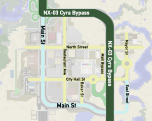
Map
Buildings
Cyra has many franchises including:
- TheSpoon (3 Restaurant Ave)
- TheSpoon Mini (2 Main St)
- Kiwi Steaks (6 Restaurant Ave)
- Kiwi Steaks Express (1a City Hall St)
- Kiwi Steaks Express (6 City Hall St)
- Kiwi Steaks (Suite 1, Kiwi Square)
- Prubourne Steak ( 3 Main St)
- Kalmar Fried Chicken (1 Restaurant Ave)
- Beefhut (6 Main St)
- BTBaker (9 Main St)
- Kiwi Steaks Express (0 City Hall Ave)
- Music's Gems
- OmriCORN Cafe (6 City Hall St)
- McMax's (6 Appeal St.)
- Frash N Easy (6 Appeal St.)
- Arlington Book Store (2 North St.)
- Dave's Doughnuts (Suite 6, Kiwi Square)
- CreeperCola (Cyra Park)
As well as a few independent restaurants including:
- Starblocks (2 Restaurant Ave)
- MRTking (Cyra Mall | 3-5 City Hall St)
- McMRT (Cyra Mall | 3-5 City Hall St)
- MRTway (Cyra Mall | 3-5 City Hall St)
Other important buildings:
- Cyra Mall (3-5 City Hall St)
- Cyra Apartment Building (4 Main St)
- Cyra City Hall (2 City Hall St)
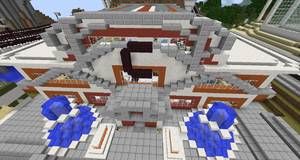
- Cyra Trade Centre & 9/11 Memorial
News
- 3 July 2013: Building on Cyra has begun.
- 30 July 2013: Cyra is now finally recognized as a town!
Transit
The Cyra Metro has three local lines and 2 express lines.
- Magenta Line (Express: Purple Line): Ravenswood- Cyra Transit Hub
- Lime Line (Express: Green Line): Kiwi Square-Cyra Transit Hub
- Cyan Line: Robin's Square- Cyra Port
Cyra Underwood Municipal Airport
Cyra's airport provides access to air travel in the northeastern part of the city. IntraAir, Eastern Airways, and Viaggio fly out of the airport from its two terminals.
