Falloway/Transportation
| Main Page | Transportation | Accommodation | Business | References |
Transit
Falloway is a small city so the most popular form of transportation is walking. Public transportation in Falloway is limited but is slowly expanding to meet the needs of the growing city. At the current time there is one operational bus line with another under construction.
Due to the terrain Falloway sits on, a metro system will be difficult to install but one is planned for the future. A section of built metro track can be seen in Lower Falloway.
Falloway is connected to the rest of the New World by the MRT Circle Line and road connections to nearby cities. Despite the status of Falloway, no major road highways connect to the city.
Water transport is limited while a commercial port is under construction. No public water transportation currently runs to the city. Water transportation that does exist include ships privately operated by Inchmuir Space Agency for research and recovery.
Bus Network
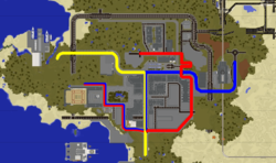
Taking the bus is a simple way of getting around Falloway quickly. To keep roads clear of obstructions, bus stops in Falloway act as the vessel for hosting warp signs. Bus stops can be identified by their design; a coloured post indicating which line the stop serves, and signage to tell the user where the stop goes next.
Blue Bus
The blue bus line connects the city centre with Falloway railway station.
Stops:
- City Hall
- City Square
- Edinburgh Road
- Bond Street
- Farmer's Market
- Railway Station C76
Yellow Bus
The yellow bus line connects the city centre with the space coast.
Stops:
- Bond Street
- Marvel Road
- Falloway Castle
Light Rail
Falloway will contain one circular light railway system. The line will contain both suburban and inner city stops. The first station in Lower Falloway is currently under construction. The light railway uses RED technology.
Road Network
Falloway is connected to the rest of the MRT Road network by a connection to Helix Bay. The Helix Bay to Falloway connection (known as the Pachi-Ampharic junction) was headed by TrainPro and is jointly maintained by both Falloway City Council and the town council of Helix Bay. The road junction uses Helix Bay's road surfacing while using Falloway's road signage format. The junction has been opened for some time but officially completed in August 2016 with the installation of the final road signs.
- Residents of Falloway who wish to drive to other parts of the MRT should follow signs for Helix Bay and if necessary take the Falloway City Bypass, exiting at Junction 3.
- Players should then follow signs for Daneburg throughout Helix Bay.
- Care should be taken while driving in Helix Bay as tunnels are not lit.
- Once in Daneburg, players should make their way North to Waverly or North-East to Kolpino City.
- Players arriving in Daneburg should note that it is not uCar friendly and that at least 3 tram crossings will need to be traversed.
- Also note that road signs in Daneburg do not exist, players are recommended to use the Dynmap for navigation.
- From Waverly or Kolpino City, these cities are well connected to the remaining New World cities, see the New World Highway System roads for more details.
City Bypass
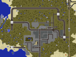
The Falloway City Bypass is a "B class" road which loops around the city. The road is a high traffic and high speed road that allows easier navigation around Falloway compared to complex inner city roads. The entire bypass is speed controlled for uCars with long stretches incorporating medium (gold) speed boosts and corners restricted to default speed.
| Status | Junction | Exit For | Connecting Roads |
|---|---|---|---|
| City Centre |
|||
| Falloway Space Centre Falloway Airport City Centre |
C720 Marvel Road | ||
| Lower Falloway Tornsea Power Station |
|||
| Helix Bay Daneburg Lower Falloway |
C71 Pachi Road | ||
| Falloway Railway Station - C76 City Centre |
C720 Marvel Road | ||
| Pamsterlin |
C750 Revolution Road |
Road Standards
Falloway's roads follow a similarly high standard to that of the city's building regulations. Fallowa's road network complies with both the MRT Road Standards and Formosa Traffic System.
Signage
Falloway Road Management implements a standardised signage formatting. The signage formatting is based off road signs in the UK.
- Materials: Green Wool (top row), Sea Lantern (bottom row), Spruce Fence
- Units: Metres
- Arrows: Quartz stairs in item frames, renamed to include destination using anvils.
- Text: Bold text for junction number or district. Un-formatted text for maximum of three destinations. Gray text for roundabout exit numbers.
Air & Space
Construction is underway on Falloway's integrated air and space facility. The facility will be jointly managed by Air Falloway, Inchmuir Space Agency (ISA) and the Falloway City Government. The airport and space centre plans were approved in October 2016 and is expected to be completed by mid-2017.
Falloway Airport
Falloway's airport will be one of the smallest on the server but its integration with the space centre will make it one of the most prominent. The airport will consist of 3-4 gates and will connect to hub airports which will provide connections throughout the server.
Falloway Space Centre
Falloway Space Centre (FSC) will be one of the most advanced spaceports on the server. Utilising ISA technologies, the space centre will consist of 3 launch pads and a payload processing facility. It will share the runway with Falloway Airport.

