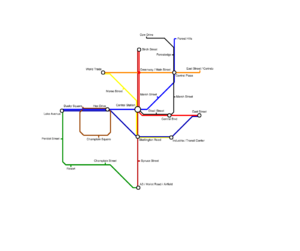
Grayzen Rapid Transit
| Grayzen Rapid Transit | |
|---|---|
 | |
| Where it Goes | |
| Route | Throughout Grayzen |
| Number of stations | 26 counting tram stops, 22 not |
| Status | Under Construction |
| Players involved | |
| Main builder | cardinalland |
| Technology | |
| Station]] | Custom |
Grayzen Rapid Transit is the main Rapid Transit serving Grayzen with subways. It currently has twenty six stations and eight subway lines, the 1 2 3 4 5 6 7 , and the Champlain Shuttle. The Avex Avenue Tram also travels through the city.
Status
| Rail Line Name | Status | Information |
|---|---|---|
| 1 Line | ||
| 2 Line | ||
| 3 Line | ||
| 4 Line | ||
| 5 Line | ||
| 6 Line | ||
| 7 Line | ||
| Champlain Shuttle |
Subway Routes
[1] - Main Street Line
The 1 line serves the Grayzen neighborhoods of New City and Residentia. It makes an L shape, currently with 8 stations:
[2] Avex Avenue Line
The 2 line serves the Grayzen neighborhoods of New City, Old City, Residentia. It goes diagonally southwest to northeast through Grayzen, making 7 stops.
[3] Main Street Express
The 3 travels express for the 1 line, with five stops. They split off after Central Station, and the 3 continues along Main Street to Mollot Road. This is currently the only line with a terminus completed, at A3 - Mollot Road, although there is room for expansion.
| Status | Code | Station name | Connections |
|---|---|---|---|
| RR1 | Birch Street | 1 | |
| XE3 | Central Station | 1 2 4 , Expo Line, [A] Tram, [20 bus] | |
| RR2 | Skellington Road | 4 5 | |
| RR3 | Spruce Street | None | |
| RR4 | A3 - Mollot Road | 6 |
[4] Skellington Road Local
The 4 line travels from Skellington Road to the 3 line. It then turns off to the northwest.
[5] Avex Avenue Express
The 5 line travels along Main Street with the 2 line, then splits off onto Skellington Road.
| Status | Code | Station name | Connections |
|---|---|---|---|
| BB1 | Landside Hills | 1 , Expo Line | |
| BB2 | East Street | 1 | |
| BB3 | Industria | 4 | |
| BB4 | Skellington Road | 3 4 | |
| BB5 | Hex Drive | 2 | |
| BB6 | Lake Avenue | 2 6 |
[6] Mollot Road Local
The 6 line runs along Lake Avenue and Mollot Road through the southern parts of Grayzen.
| Status | Code | Station name | Connections |
|---|---|---|---|
| G1 | East Street - Laminole | 4 , RailinQ | |
| G2 | A3 - Mollot Road | 3 | |
| G3 | Champlain Street | None | |
| G4 | Resort | None | |
| G5 | Peridot Street | None | |
| G6 | Lake Avenue | 2 5 |
[7] Greenway Local
The 7 runs under the Greenway, the main shopping district.
| Status | Code | Station name | Connections |
|---|---|---|---|
| O1 | Colindo / East Street | None | |
| O2 | Central Plaza | 2 , [A] Tram | |
| O3 | Main Street | 1 | |
| O4 | World Trade Center | 4 |
[S] Champlain Shuttle
The S is a special shuttle to service Champlain Square, making 3 stops. It only goes one way around.
| Status | Code | Station name | Connections |
|---|---|---|---|
| C1 | Hex Drive | 2 5 | |
| C2 | Dusky Square | 2 | |
| C3 | Champlain Square | None |
Tram Routes
[A] Avex Avenue Tram
The A Avex Avenue Tram travels from Central Station to Hex Drive on Swilner Street.
Bus Routes
[20] Greenway Bus
The 20 bus travels from Central Station to Central Plaza, making 4 stops.
| Status | Code | Station name | Connections |
|---|---|---|---|
| XE3 | Central Station | 1 3 2 4 , Expo Line, [A] Tram | |
| BA1 | Marsh/Main Street (planned) | None | |
| BA2 | Greenway/Cow Drive (planned) | None | |
| BA3 | Central Plaza | 2 |
Note: This bus currently goes directly between Central Station and Central Plaza, skipping planned stops.
Service Changes
Station Revitalization
This is not necessarily a service change, but an improvement system. Stations across the GZRT (Including the tram) will be upgraded to have key features including:
- ECDs (Empty Cart Detectors) at every stop
- Call Cart mechanisms at every stop
There will also be some renovations on older stations. Stations will not be closed, but there maybe some construction on tracks.
Expansion Plans
None right now.
Abandoned Stations
City Hall
Between Central Station and Central Blvd on the 1 line there lies a station which has many cobwebs. It is seen best on the Central Blvd side as a set of tracks that disappears into the distance diagonally to the right. At the end is the station, which connects with a hidden underground street full of cobwebs.