MRT Island Line
| MRT Island Line | |
|---|---|
 | |
| Route | Central City to Cape Cambridge via Elecna Bay and Victoria |
| Number of stations | 61 |
| Players involved | |
| Main builder | jphgolf4321: Original section SimonScholar: Island Extension 1 I28 - I42 SimonScholar: Island Extension 2 I43 - I61 |
| Additional builders | thomasfyfe Music3_0: I10 to I13 _MajorMagpie_: I14 to I20 _frozen: I21 to I27 |
| Technology | |
| Station | MRT v5 |
The MRT Island Line, or simply the Island Line, is one of the 22 lines of the New World MRT System and one of the 11 initial New World MRT lines built in conjunction with the Gamma server update.
History
The Island Line was one of the 11 initial lines built in New World. The initial section goes from Central City Southeast Terminal to Fort Yaxier.
The Island Line was first mentioned in the New World MRT plans in August 2014. The route it took according to the plan is Central City to Tribiome Island then it would have extended east from the island to one of the southeast terminals, being shared with Plains and Eastern Lines. The line most likely got its name from Tribiome Island, which the line originally terminated at.
In Frumple's Epsilon MRT plans at the May 2017 GSM, the Island Line was suggested to be extended to the south to MRT Southern Line, where Aeolia is.
In the February 2018 GSM, the Island Line routing was changed. Instead, it took a further western routing, connecting at Edwardsburg and Valley Line's routing changed so it took Frumple's old Island Line routing, connecting at Aeolia.
In the August 2018 GSM, SimonScholar (called godzilltrain at this time) proposed an extension of Island and Valley Lines to connect with Southern Line. Both extensions opened in January 2019 GSM.
In the Zeta MRT plans by Frumple at April 2020, the Island Line would be extended to the southwest, and it has 2 possible alignments, with one terminating on the island at the south and the other terminating at the far southwest, with the choice of routing used would determining where Desert Line would terminate at.
In the March 2022 GSM, SimonScholar proposed another extension, extending the line to Cape Cambridge. It was completed in April 18, 2022 and the extension opened along with Zephyr South extension in May 2022 GSM.
As part of the Zeta MRT planning in August 2022, many people, including SimonScholar and jay_planner suggested that the line should be extended a short distance south to the island. However, Frumple's plan suggested to extend the Island Line to the far southwest, and this was affirmed in the final Zeta MRT plan.
Route
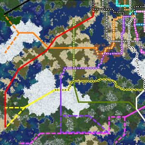
The Island Line commences at Central City and terminates at Cape Cambridge via the Premier city of Elecna Bay. The current travel duration for the line's entire length is approximately 89 minutes.
Original section (I1 - I27)
The line begins at Central City SE Terminal, with transfers to a shared section between MRT Forest Line and MRT Zephyr Line begins, and MRT Mesa Line in Central City SE. In the shared section, MRT Forest Line and MRT Island Line run parallel together, with MRT Zephyr Line tracks being below the MRT Forest Line. The style in this section is like the early MRT lines built pre-Gamma; quartz bottoms with magenta wool lines going down the center and sides with redstone lamps placed along the way, with 3-high tunnels, and quartz columns placed, and torches along the sides in viaducts.
The lines then cross A0, leaving Central City and entering Royal Ferry. In Royal Ferry, the MRT Zephyr Line splits off from the section on the way to Segville just after F2 station, and at around F3 station where the lines crosses the mountains, MRT Forest Line and MRT Island Line take different routings, with MRT Forest Line platforms being located lower compared to MRT Island Line platforms in F3. After this station, the line then rises to be level with MRT Island Line, and this continues into Oakley, descending slightly, where MRT Forest Line turns to the east, going to Dabecco and points beyond, and MRT Island Line continues straight.
Then, the line goes across to the south, passing through Magepond, Conricsto and Matheson, staying mostly in a viaduct, except for brief sections at I13. After passing through I11 station and crossing A51, the line then goes across the desert biome on the way to Elecna Bay. After 2 stations, the line enters a concurrency with MRT Circle Line, running below its tracks until I20, via Inverness. This section is one of the two MRT line sections where one line counts up while the other line counts down, with the MRT Circle Line counting up and the MRT Island Line counting down. The other MRT section that has this feature is the MRT Lakeshore Line and MRT Zephyr Line section between stations LW4/ZN35 and Oparia.

After the concurrency with MRT Circle Line, the line passes through Elecna Bay, mostly running in viaducts, with some ground segments. After I23 station, which serves the Elecna Bay International Airport, the line then goes underground, passing through I24 station, before going back above ground to Fort Yaxier, cutting through a road on the way to I25. In Fort Yaxier, it has a station serving Fort Yaxier Airfield, at I26 and a station serving Fort Yaxier Central Station at I27.
Island Line Extension (I28 - I42)
While still in Fort Yaxier, after passing through Fort Yaxier Central Station. the concurrency with MRT Valley Line starts. In the concurrency, it passes through Fort Yaxier Sports Park, then crossing a canal connecting Elecna Bay (lake) and Lake 19, then passing through Fort Yaxier International Airport, which is served by 2 stations: I29 and I30. Like all other extensions built by SimonScholar, the style of this extension is much like early MRT extensions except with viaducts having magenta wool sides with white glass barriers, and 4-high tunnels.
Then, the line enters the southern tundra region, ascending above ground. While passing through the region, it passes through MeTromso and Southburg. In Southburg, the concurrency ends, with MRT Valley Line going to Aeolia and MRT Island Line going to Edwardsburg. The line then passes through Snowfall, at I38 before the line goes underground to cross Equinox Ocean, before passing through Victoria, which is served by 2 stations, at I40 and I41, before Edwardsburg which is served by I42 station and has a transfer to MRT Southern Line.
Island Line Extension 2 (I43 - I61)
After passing through I42 station, the line then enters Meridia, paralleling A54 up all the way to Rattlerville, passing through Sandfield on the way. The extension uses the same style found in SimonScholar's other extensions. The line turns to the southeast in Rattlerville, passing through Port Diamondback and Tingarla, going underground after Tingarla to pass through the roofed forest and Port Sonder, and a canal connecting Equinox Ocean and Lake 49.
Then, the line then goes above ground, going through Denmoter and Toronto, where you can transfer to MRT Zephyr Line and MRT Oasis Line. Then, the line goes through forest biomes and Brinhead before ending in Cape Cambridge, with 2 stations: I60 and I61, with the latter having a transfer to MRT Union Line.
Cities
| City | Rank | Mayor | Stations |
|---|---|---|---|
| Royal Ferry | [Senator] | MIKE24DUDE | I2 Royal Ferry Paddington Station I3 Royal Ferry Waterloo Station I4 Royal Ferry Kensington (Olympia) I5 Oakley Euston |
| Elecna Bay | [Premier] | mine_man_ | I20 Kelvinside I21 Elecna Bay - Restraunt District I22 Elecna Bay - Southside I23 Elecna Bay Intl Airport I24 Elecna Bay - FYI Interchange |
| Fort Yaxier | [Governor] | camelfantasy | I24 Foobar I25 Fort Yaxier West I26 Fort Yaxier Airfield I27 Fort Yaxier Central I28 Fort Yaxier Sports Park I29 FYI Terminal 1 I30 FYI Terminal 2 |
| Victoria | [Senator] | MC_Protocol | I40 Victoria - Coastal Point I41 Victoria Preston |
| Rattlerville | [Senator] | kingsnake | I46 Rattlerville Old Town I47 Rattlerville Central |
| Port Sonder | [Governor] | TheThirdOdd | I51 Port Sonder East I52 Port Sonder West |
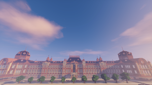
| Cape Cambridge | [Senator] | PaintedBlue | I60 Cape Cambridge - Northland Transit Center I61 Cape Cambridge - Piazza dell'Unita |
Stations
| Status | Code | Station name | MRT connections | |
|---|---|---|---|---|
| Central City | ||||
| I1 | Southeast Terminal | MX MRT Mesa Line F1 MRT Forest Line ZS1 MRT Zephyr Line | ||
| Ward 5 | ||||
| I2 | Royal Ferry Paddington Station | F2 MRT Forest Line ZS2 MRT Zephyr Line | ||
| I3 | Royal Ferry Waterloo Station | F3 MRT Forest Line | ||
| I4 | Royal Ferry Kensington- Olympia | F4 MRT Forest Line | ||
| I5 | Oakley Euston | F5 MRT Forest Line | ||
| I6 | ||||
| I7 | ||||
| I8 | ||||
| I9 | ||||
| I10 | ||||
| I11 | ||||
| I12 | ||||
| I13 | ||||
| I14 | C57 MRT Circle Line | |||
| I15 | C56 MRT Circle Line | |||
| I16 | C55 MRT Circle Line | |||
| I17 | C54 MRT Circle Line | |||
| I18 | C53 MRT Circle Line | |||
| I19 | C52 MRT Circle Line | |||
| I20 | C51 MRT Circle Line | |||
| I21 | Elecna Bay Boardwalk District | |||
| I22 | Elecna Bay SouthSide | |||
| I23 | ||||
| I24 | ||||
| I25 | Fort Yaxier West | |||
| I26 | Fort Yaxier Airfield | |||
| I27 | Fort Yaxier Central Station | V30 MRT Valley Line | ||
| I28 | Fort Yaxier Sports Park | V31 MRT Valley Line | ||
| I29 | FYI Terminal 1 | V32 MRT Valley Line | ||
| I30 | FYI Terminal 2 | V33 MRT Valley Line | ||
| I31 | V34 MRT Valley Line | |||
| I32 | V35 MRT Valley Line | |||
| I33 | V36 MRT Valley Line | |||
| I34 | V37 MRT Valley Line | |||
| I35 | V38 MRT Valley Line | |||
| I36 | V39 MRT Valley Line | |||
| I37 | ||||
| I38 | ||||
| I39 | ||||
| Ward 4 | ||||
| I40 | Victoria - Coastal Point | |||
| I41 | Victoria - Preston | |||
| I42 | Victoria - South | SE5 MRT Southern Line | ||
| I43 | ||||
| I44 | Sandfield | |||
| I45 | ||||
| I46 | Rattlerville Old Town | |||
| I47 | Rattlerville Central | |||
| I48 | ||||
| I49 | ||||
| Ward 5 | ||||
| I50 | ||||
| I51 | Port Sonder East | |||
| I52 | Port Sonder West | |||
| I53 | ||||
| I54 | ||||
| I55 | ZS55 MRT Zephyr Line O0 MRT Oasis Line | |||
| I56 | ||||
| I57 | ||||
| I58 | ||||
| I59 | ||||
| I60 | Cape Cambridge Northland Transit Center | |||
| I61 | Cape Cambridge Piazza dell'Unita | |||

