Kantō
| Kantō 関東 | |
|---|---|
 Flag of Kantō | |
| Officials | |
| Founder | camelfantasy |
| Mayor | MikeRoma |
| Town recognition | |
| Rank | Governor |
| Date founded | August 29, 2017 |
| Date recognized as Councillor | October 22, 2017 |
| Geography | |
| Town hall coordinates | 6900, 70, 10100 |
| World | New World |
| Ward(s) | Ward 4 |
| Post code(s) | KA4 |
| Transit | |
| Air facilities | Kantō Airfield Kantō International Airport |
| Local transit | Kantō Bus Kantō Railways |
| Etymology | |
| Language(s) | English (Main) Japanese Traditional Mandarin |
| Political affiliations | |
| State | Republic of Formosa |
| Lore | |
| Population | 2 |
Kantō (commonly written as Kanto for simplicity) is a city located in the southern and far eastern area of the New World. The general style of the city is based largely on urban Japan and Taiwan.
Administration
Kantō is governed largely by the mayor, with the deputy mayor assisting as well as the five main commissioners of the military, foreign affairs, internal affairs, citizen welfare, and finance. Legislative duties are under the charge of the Speaker of Senate, and judicial issues are resolved under the Chief Justice.
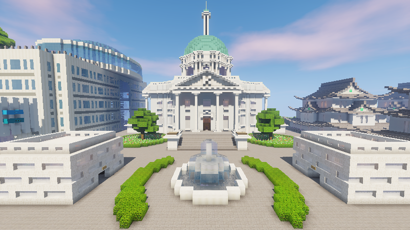
The government is headquartered in the Government Ward within a number of buildings, largely consisting of offices for the five commissioners' departments. The heads of each branch as well as the Executive Function have offices located in the City Hall, while the 51-seat State Senate has offices and meeting areas in the City Assembly Hall and Offices, and the 3-justice State Court resides in the City Courthouse.
The Tokaidō Metropolitan Government is a planned regional administration consisting of Kantō and its surrounding cities, the Tokaidō Metropolitan Area. Its headquarters will be in the planned Palace of Kantō, a large building containing all the assembly chambers and offices and its surrounding grounds.
Wards
Kantō is divided into several wards for local governance, most of which serve a specialized and unique purpose. The city center will consist of the Business, Commercial, Education, Entertainment, and Government Wards, which are roughly divided by rivers and will meet in the center of the city. Surrounding areas will consist of Beach, Industrial, and Military Wards with remaining space used by multiple residential wards, as well as some secondary commercial wards.
Currently existing wards:
- Business
- Entertainment
- Government
- Industrial
- Military
- Poppy Hill (residential)
- Commercial
- Education
Buildings
- City Hall
- City Assembly Hall
- City Courthouse
- City Assembly Station
- Court Police
- Court Lawyers Offices
- Central Police Station
- City Assembly Offices
- Central Fire Station
- Kantō Lobbying Consortium tower
- Department of Citizen Welfare
- Department of Finance
- Department of Internal Affairs
- Kantō Orchestra on Water Lounge
- Department of Military
- Department of Foreign Affairs
- Kantō Central Hospital
- Ghibli Museum
- Cinema Reale
- Kantō KTV
- Kantō Stadium
- Bowling Alley
- Stone Pub
- Mini Country Club
- Nightclub
- Arcade
- Government Ward Administration
- Government Residences Tower
- Brick Bar
- Ristorante Lago
- State Residence (Mayor)
- State Residence (Deputy Mayor)
- State Residence (Speaker of Senate)
- State Residence (Chief Justice)
- Kantō Station
- Kantō Life
- Fantasia Inc. Regional Headquarters
- Kantō Railways Headquarters
- Kantō Airfield Terminal 1
- Kantō Airfield Terminal 2
- Kantō Convention Center
- Chūō Shinkansen Station
- Residence P1
- Residence P2
- Poppy Hill Station
- Tacurger Shack
- Eat and Bowl
- Residence P3
- Lawson's (Poppy Hill)
- Departments Plaza Station
- Le Midi Hotel
- Business Ward Administration
- Nature Preservation Society
- Bank of Kantō
- Red Brick Warehouse 1 (Kantō Port)
- Red Brick Warehouse 2 (Kantō Port)
- Lift Operations
- Storage
- Troop Baracks 1
- Troop Baracks 2
- Officer Quarters
- Armory
- Communications and Sensors
- Grotto Pizza
- Chicago's Popcorn
- Poppy Hill Rear Station
- Poppy Hill Administration
- Kantõ Shipping Headquarters
- Kantõ Accountability Office
- Waterfront Restaurant and Bar
- Residence P4
- Unnamed Department Store
- Kura Sushi
- The Tech Store
- COFFEE COFFEE & Bubbler
- Yodobashi Camera
- Sunshine Coast Defence Force Kantō Base
- Warehouse 1
- Warehouse 2
- Warehouse 3
- Red Brick Warehouse 1 (Kantō Canal)
- Red Brick Warehouse 2 (Kantō Canal)
- Kantō Fish Market
- Warehouse 4
- Warehouse 5
- Warehouse 6
- Kantō Aquatics Center
- Kantō Senior High School
- Kantō Senior High School Gymnasium
- Kantō Senior High School Stadium
- Kantō Vehicle Center Kantō Railways Maintenance Facility
- Kantō Vehicle Center High Speed Rail Corporation Maintenance Facility
- Apex Towers (NE Tower)
- Apex Towers (NW Tower)
- Apex Towers (SW Tower)
- Apex Towers (SE Tower)
- Kantō Senior High School Baseball Stadium
- Kantō Elementary School
- Kantō Elementary School Library
- Kantō Elementary School Auditorium
- Kantō Elementary School Gymnasium
- Kantō Elementary School Pool
- Kantō Elementary School Station
Rear square of the Kantō State Court
Lake on the Kohaku River.
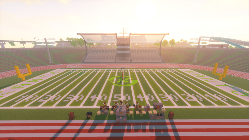
Kantō Stadium in use by a marching band.
Kantō Convention Center in use by HSRC.
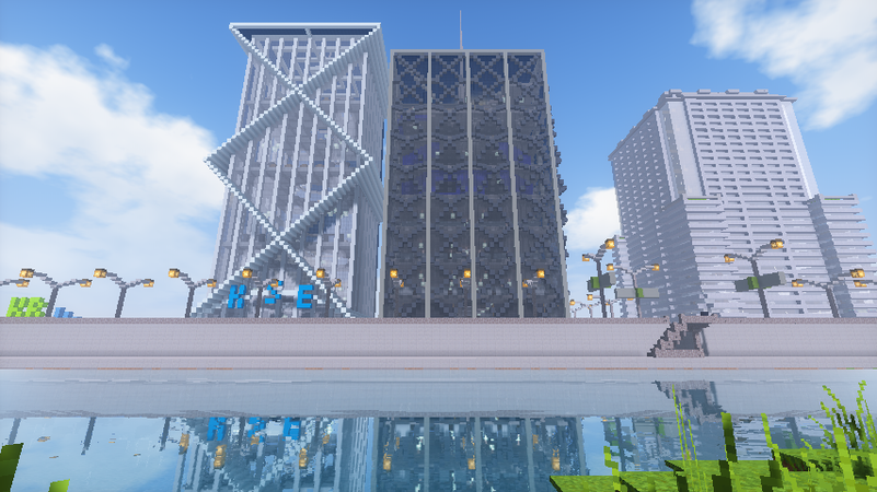
Kantō Business Ward.
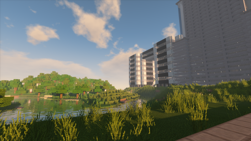
Kohaku River along the Business Ward.
Poppy Hill residential ward before expansion.
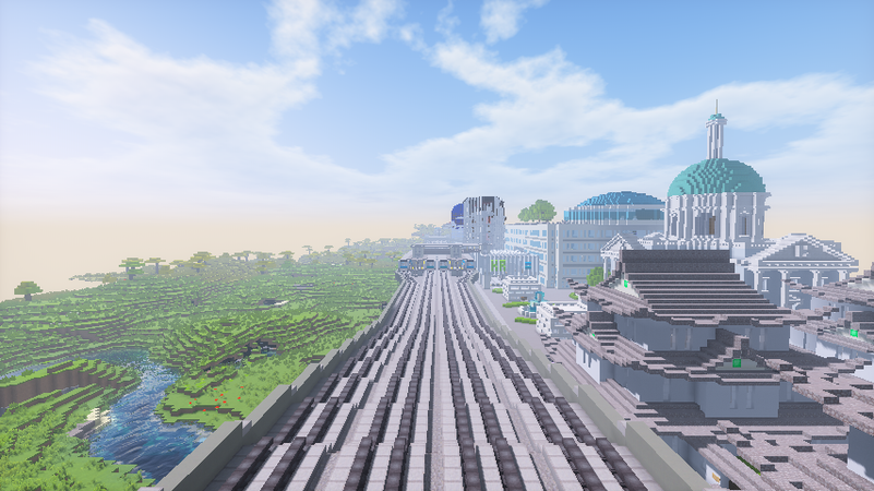
Looking west down the Tozai Line.
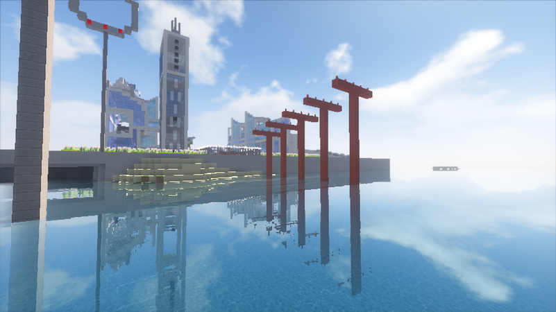
Kantō Airfield from the Equinox Ocean to the west.
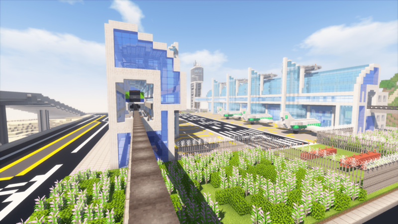
Terminal 1's entrance area.
Kantō Monorail station in Terminal 2.
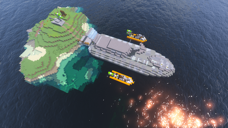
Minor outlying island being
invadedsurveyed by the Formosa Armed Forces.


Points of Interest
- Kantō Orchestra on Water - located north of Mei Kusakabe Road
- Totoro Statue - intersection of Miyazaki Avenue and Totoro Road
- Ashiyu/Teyu - NE corner of the intersection of Miyazaki Avenue and Chihiro Ogino Road
- Flagpole bearing two flags translated as "I pray for safe voyages" - one north of Government Residences Tower and one east of Kanto Convention Center
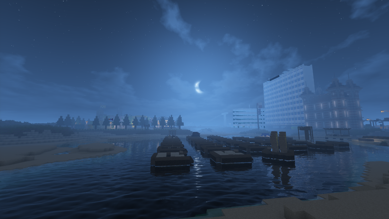
- Kantō Port - large port area with container storage areas and warehouses and is served by both road and rail
- Fort Kantō - Kantō's main military base with an army section on the mainland and a naval section on an adjacent island
- Kantō Canal - canal lined with former warehouses that have been converted for commercial use
- Kantō Nets - outdoor athletics complex divided into four areas for different net sports
Transportation
Traveling around the city will be greatly focused on public transportation, from commuter rails to buses. All transportation services and hubs within the city as well as some services to the surrounding Tōkaido Metropolitan Area are operated by Kantō Railways.
Notably, all roadway vehicles and trains drive on the left side, unlike most other cities.
Rail

Commuter rail will compose of the majority of the rail network. The overall network will resemble four through lines angled roughly the same from each other and meeting at a central station, with two loop lines, one in the downtown area and one near the city perimeter. Towards the center of the city, the cardinal directional lines will serve as express trains while the other lines on the same tracks will serve as local trains. All rolling stock consists of E233-series 3-car trainsets.
Metros, light rails, and monorails may be considered for use, with metros and monorails serving a limited number of wards and covering unserved areas by the commuter rail, and light rail serving as more local service in single wards.
Stations with gray backgrounds indicate stations under construction, and stations with pink backgrounds indicate planned [direction of] extensions.
Yamanote Line
The Yamanote Line is planned to run in a loop along the outer perimeters of the city and connect to all of the other commuter rail lines.
| Line name | No. | Station | Transfers | Location |
|---|---|---|---|---|
| Yamanote Line | KY
?? |
Business Ward | ||
KAN
KY
01 |
Kantō Station | KC Chūō Line KN Namboku Line KT Tōzai Line KS Nansei Line KA Nantō Line KO Tōhoku Line KH Hokusei Line | ||
KTIA
KY
02 |
Kantō International Airport Terminal 1 | KN Namboku Line | ||
KTIB
KY
03 |
Kantō International Airport Terminal 2 | KN Namboku Line | ||
KY
?? |
Chūō Line
The Chūō Line is planned to run in a loop along the downtown area of the city and serve as a connector among all other transit services.
| Line name | No. | Station | Transfers | Location |
|---|---|---|---|---|
| Yamanote Line | KC
?? |
Business Ward | ||
KAN
KC
01 |
Kantō Station | KY Yamanote Line KN Namboku Line KT Tōzai Line KS Nansei Line KA Nantō Line KO Tōhoku Line KH Hokusei Line | ||
WTC
KC
02 |
World Trade Center | KA Nantō Line | ||
| Chūō Line | WTS
KC
03 |
World Trade Center South | ||
KES
KC
04 |
Kantō Elementary School | KM Kantō Monorail |
Education Ward | |
KJH
KC
05 |
Kantō Junior High School | |||
KTU
KC
06 |
Kantō University | KP Plateau Monorail | ||
KC
07 |
Namboku Line
The Namboku Line is planned to run north-south through the city.
| Line name | No. | Station | Transfers | Location |
|---|---|---|---|---|
| Yamanote Line | KN
?? |
Business Ward | ||
KAN
KN
?? |
Kantō Station | KY Yamanote Line KC Chūō Line KT Tōzai Line KS Nansei Line KA Nantō Line KO Tōhoku Line KH Hokusei Line | ||
KTIA
KN
?? |
Kantō International Airport Terminal 1 | KY Yamanote Line | ||
KTIB
KN
?? |
Kantō International Airport Terminal 2 | KY Yamanote Line | ||
KN
?? |
Tōzai Line
| Tōzai Line | |||||||||||||||||||||||||||||||||||||||||||||||||||||||||||||||||||||||||||||||||||||||||||||||||||||||||||||||||||||||||||||||||||||||||||||||||||||||||||||||||||||||||||||||||||||||||||||||||||||||||||||||||||||||||||||||||||||||||||||||||||||||||||||||||||||||||||||||||||||||||||||||||||||||||||||||
|---|---|---|---|---|---|---|---|---|---|---|---|---|---|---|---|---|---|---|---|---|---|---|---|---|---|---|---|---|---|---|---|---|---|---|---|---|---|---|---|---|---|---|---|---|---|---|---|---|---|---|---|---|---|---|---|---|---|---|---|---|---|---|---|---|---|---|---|---|---|---|---|---|---|---|---|---|---|---|---|---|---|---|---|---|---|---|---|---|---|---|---|---|---|---|---|---|---|---|---|---|---|---|---|---|---|---|---|---|---|---|---|---|---|---|---|---|---|---|---|---|---|---|---|---|---|---|---|---|---|---|---|---|---|---|---|---|---|---|---|---|---|---|---|---|---|---|---|---|---|---|---|---|---|---|---|---|---|---|---|---|---|---|---|---|---|---|---|---|---|---|---|---|---|---|---|---|---|---|---|---|---|---|---|---|---|---|---|---|---|---|---|---|---|---|---|---|---|---|---|---|---|---|---|---|---|---|---|---|---|---|---|---|---|---|---|---|---|---|---|---|---|---|---|---|---|---|---|---|---|---|---|---|---|---|---|---|---|---|---|---|---|---|---|---|---|---|---|---|---|---|---|---|---|---|---|---|---|---|---|---|---|---|---|---|---|---|---|---|---|---|---|---|---|---|---|---|---|---|---|---|---|---|---|---|---|---|---|---|---|---|---|---|---|---|---|---|---|---|---|---|---|---|---|
| |||||||||||||||||||||||||||||||||||||||||||||||||||||||||||||||||||||||||||||||||||||||||||||||||||||||||||||||||||||||||||||||||||||||||||||||||||||||||||||||||||||||||||||||||||||||||||||||||||||||||||||||||||||||||||||||||||||||||||||||||||||||||||||||||||||||||||||||||||||||||||||||||||||||||||||||
The Tōzai Line is planned to run east-west through the city, following a rough path north from the beach areas, then curving and heading almost directly east.
| Line name | No. | Station | Transfers | Location |
|---|---|---|---|---|
| Tōzai Line | KT
01 |
Business Ward | ||
KAN
KT
02 |
Kantō Station | KY Yamanote Line KC Chūō Line KN Namboku Line KS Nansei Line KA Nantō Line KO Tōhoku Line KH Hokusei Line | ||
CAS
KT
03 |
City Assembly | KS Nansei Line
|
Government Ward | |
PPH
KT
04 |
Poppy Hill | KP Plateau Monorail |
Poppy Hill Ward | |
KT
05 |
Nansei Line
| Nansei Line | |||||||||||||||||||||||||||||||||||||||||||||||||||||||||||||||||||||||||||||||||||||||||||||||||||||||||||||||||||||||||||||||||||||||||||||||||||||||||||||||||||||||||||||||||||||||||||||||||||||||||||||||||||||||||||||||||||||||||||||||||||||||||||||||||||||||||||
|---|---|---|---|---|---|---|---|---|---|---|---|---|---|---|---|---|---|---|---|---|---|---|---|---|---|---|---|---|---|---|---|---|---|---|---|---|---|---|---|---|---|---|---|---|---|---|---|---|---|---|---|---|---|---|---|---|---|---|---|---|---|---|---|---|---|---|---|---|---|---|---|---|---|---|---|---|---|---|---|---|---|---|---|---|---|---|---|---|---|---|---|---|---|---|---|---|---|---|---|---|---|---|---|---|---|---|---|---|---|---|---|---|---|---|---|---|---|---|---|---|---|---|---|---|---|---|---|---|---|---|---|---|---|---|---|---|---|---|---|---|---|---|---|---|---|---|---|---|---|---|---|---|---|---|---|---|---|---|---|---|---|---|---|---|---|---|---|---|---|---|---|---|---|---|---|---|---|---|---|---|---|---|---|---|---|---|---|---|---|---|---|---|---|---|---|---|---|---|---|---|---|---|---|---|---|---|---|---|---|---|---|---|---|---|---|---|---|---|---|---|---|---|---|---|---|---|---|---|---|---|---|---|---|---|---|---|---|---|---|---|---|---|---|---|---|---|---|---|---|---|---|---|---|---|---|---|---|---|---|---|---|---|---|---|---|---|---|
| |||||||||||||||||||||||||||||||||||||||||||||||||||||||||||||||||||||||||||||||||||||||||||||||||||||||||||||||||||||||||||||||||||||||||||||||||||||||||||||||||||||||||||||||||||||||||||||||||||||||||||||||||||||||||||||||||||||||||||||||||||||||||||||||||||||||||||
The Nansei Line is planned to run from the southwest of the city to its center. Its overall path outside the central area has yet to be determined.
| Line name | No. | Station | Transfers | Location |
|---|---|---|---|---|
| Tōzai Line | KAN
KS
01 |
Kantō Station | KY Yamanote Line KC Chūō Line KN Namboku Line KT Tōzai Line KA Nantō Line KO Tōhoku Line KH Hokusei Line |
Business Ward |
HWF
KS
02 |
Haku Waterfront | KM Kantō Monorail | ||
CAS
KS
03 |
City Assembly | KT Tōzai Line
|
Government Ward | |
DPT
KS
04 |
Departments Plaza | |||
| Nansei Line | KS
05 |
Nantō Line
The Nantō Line is planned to run from the southeast of the city to its center.
| Line name | No. | Station | Transfers | Location |
|---|---|---|---|---|
| Yamanote Line | KAN
KA
01 |
Kantō Station | KY Yamanote Line KC Chūō Line KN Namboku Line KT Tōzai Line KS Nansei Line KO Tōhoku Line KH Hokusei Line |
Business Ward |
WTC
KA
02 |
World Trade Center | KC Chūō Line | ||
| Nantō Line | KA
03 |
Tōhoku Line
The Tōhoku Line is planned to run from the northeast of the city to its center.
| Line name | No. | Station | Transfers | Location |
|---|---|---|---|---|
| Yamanote Line | KAN
KO
01 |
Kantō Station | KY Yamanote Line KC Chūō Line KN Namboku Line KT Tōzai Line KS Nansei Line KA Nantō Line KH Hokusei Line |
Business Ward |
KO
02 |
Hokusei Line
The Hokusei Line is planned to run from the northwest of the city to its center.
| Line name | No. | Station | Transfers | Location |
|---|---|---|---|---|
| Tōzai Line | KAN
KH
01 |
Kantō Station | KY Yamanote Line KC Chūō Line KN Namboku Line KT Tōzai Line KS Nansei Line KA Nantō Line KO Tōhoku Line |
Business Ward |
| Hokusei Line | STA
KH
02 |
Kantō Stadium | KM Kantō Monorail | Entertainment Ward |
KH
03 |
Kantō Monorail
The Kantō Monorail is planned to run from Kantō Airfield to Kantō International Airport via the Entertainment and Business Wards. The line is operated by 10000-series 3-car trainsets. At Kantō Airfield, monorails will alternate arriving at Terminal 1 or Terminal 2, splitting tracks just after Kantō Convention Center.
| Line name | No. | Station | Transfers | Location |
|---|---|---|---|---|
| Main Line | KTAA
KM
01A KTAB
KM
01B |
Kantō Airfield North Kantō Airfield South |
Flights | Entertainment Ward |
KCC
KM
02 |
Kantō Convention Center |
| ||
STN
KM
03 |
Kantō Stadium North | |||
STA
KM
04 |
Kantō Stadium East | KH Hokusei Line | ||
HWF
KM
05 |
Haku Waterfront | KS Nansei Line | Business Ward | |
KES
KM
06 |
Kantō Elementary School | KC Chūō Line | Education Ward | |
???
KM
07 |
? | |||
???
KM
08 |
Kantō International Airport North (tentative name) | Business Ward |
Plateau Monorail
The Plateau Monorail is planned to run from Poppy Hill Ward through the plateaus in the southern areas of Kantō. The line is a suspended railway and is operated by 5000-series 3-car trainsets.
| Line name | No. | Station | Transfers | Location |
|---|---|---|---|---|
| Main Line | PHM
KP
01 |
Poppy Hill Monorail Station | KT Tōzai Line |
Poppy Hill Ward |
KTU
KP
02 |
Kantō University | KC Chūō Line | Education Ward | |
KP
03 |
Hokkaidō Shinkansen
The Hokkaidō Shinkansen runs from Kantō Station to Fort Yaxier Central Station, with a possible extension to Formosa. The line is operated by H5-series 10-car trainsets.
| Station | Transfers | Location |
|---|---|---|
| Kantō Station | KY Yamanote Line KC Chūō Line KN Namboku Line KT Tōzai Line KS Nansei Line KA Nantō Line KO Tōhoku Line KH Hokusei Line |
Kantō |
| Fort Yaxier Central Station | BluRail [4] IntraRail Doppelgänger Manukau Palmetto |
Fort Yaxier |
Air
Kantō Airfield is the second largest air facility in the city, with 10 plane gates and 8 helipads. It is served by the Kantō Monorail as well as both Chihiro Ogino Road and [Unnamed] Road.
Kantō International Airport is the main air facility for the city and surrounding regions, and is served by the Yamanote and Namboku Lines as well as Hisaishi Avenue.
An intracity helicopter shuttle service operated by SkyTrans flies between these air facilities as well helipads on top of the Kantō City Assembly Offices (KTC) and [TBD].
Roadways
All roads follow an unique naming convention where major roads are named after notable contributors to Studio Ghibli while smaller roads are named after the characters from its many films.
Driving is slightly different in Kantō due to major avenues being subdivided into four median-separated sections (two express for better travel and two local for accessing buildings and curbside parking). At the intersection, inner lanes may only continue straight, turn right, or cross into the outer lanes, while the outer lanes may do the same but may only turn left instead of right. Lane interchanges located along the road and intersection lane changes facilitate vehicles needing to get to the proper roadway section for the appropriate turn lane.
Bus stops on major avenues are located on the outer medians immediately before intersections, and thus next to crosswalks for the passengers.
Bus
Buses mainly serve as shuttles to and from rail stations, and as a more mobile version of the light rail.
| Status | Code | Station name | Connections |
|---|---|---|---|
| 1.1 | Kantō Station | See below for rail connections | |
| 1.2 | Kantō Stadium | None | |
| 1.3 | Kantō Convention Center | KM Kantō Monorail | |
| 1.4A | Kantō Airfield Terminal 1 | See page for air/rail connections | |
| 1.4B | Kantō Airfield Terminal 2 | See page for air/rail connections |
Note: Buses are bidirectional at Kantō Stadium and Kantō Convention Center. At Kantō Airfield the bus is unidirectional from Terminal 1 to Terminal 2.
| Status | Code | Station name | Connections |
|---|---|---|---|
| 2.1 | Kantō Station (closed) | See below for rail connections | |
| 2.2 | City Hall (closed) | None | |
| 2.3 | Kantō Stadium (closed) | None | |
| 2.4 | Departments Plaza East (closed) | Hanamura Shuttle | |
| 2.5 | Departments Plaza West (closed) | None |
| Status | Code | Station name | Connections |
|---|---|---|---|
| G.1 | City Assembly Station | KT Tōzai Line KS Nansei Line | |
| G.2 | Ghibli Museum | None |
List of Roads
North-south roads listed from the east:
- Takahata Avenue
- Yupa Road
- Zeniba Road
- Yubaba Road
- Chihiro Ogino Road
- Ponoc Road1
- Mei Kusakabe Road
- Totoro Road2
- Catbus Road
East-west roads listed from the north:
- [Unnamed Road]
- [Unnamed Road]
- Totoro Road2
- Ponoc Road1
- Miyazaki Avenue
- Umi Matsuzaki Road
- Satsuki Kusakabe Road
- Nausicaä Road
Note: roads with matching superscripts indicate that they are the same road, but have changed orientation/relative location at least once.
Waterways
Several rivers are located within Kantō as well as a large ocean, the former of which are used for river cruises and as well as small-scale recreation. Ports along the ocean shore will provide boat access to other cities.
Boat
Hanamura Shuttle
- Kantō Orchestra on Water
- Hanamura Chihiro Ogino Park
List of Rivers
- Kohaku River - located north of Government Ward
Transit Hubs
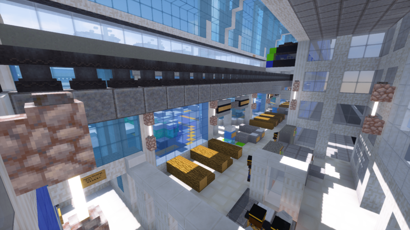
Kantō Station is Kantō's largest transit hub, located near the east end of the city, with 24 intercity and intracity tracks across three levels. 16 intracity tracks are located on two floors above the main concourse and 8 intercity tracks are located on one underground floor. A bus station adjacent to the station has 8 bus slots.
One interesting aspect of the station is a train departure chime located on four of the platforms: between tracks 3&4, 5&6, 11&12, and 13&14. The chime is an arrangement of four measures from the sixth movement of Leoš Janáček's Suite for Strings.
Tracks are numbered from north to south or east to west, starting from the top floor.
| Level 3 ← North | ||
| 1 | ■Nantō Line → | Kantō Railways services for World Trade Center. |
| 2 | ■Tohoku Line ← | Kantō Railways services for Unknown. |
| 3 | ■Yamanote Line → | Kantō Railways services for Kantō International Airport Terminal 2. |
| 4 | ■Namboku Line → | Kantō Railways services for Kantō International Airport Terminal 2. |
| 5 | ■Namboku Line ← | Kantō Railways services for Unknown. |
| 6 | ■Yamanote Line ← | Kantō Railways services for Unknown. |
| 7 | ■Chuō Line → | Kantō Railways services for Kantō University. |
| 8 | ■Chuō Line ← | Kantō Railways services for Unknown. |
| Level 2 ← West | ||
| 9 | ■Hokusei Line ← | Kantō Railways services for Kantō Stadium. |
| 10 | ■Hokusei Line ← | Kantō Railways services for Kantō Stadium. |
| 11 | ■Unknown | Unknown services for Unknown. |
| 12 | ■Unknown | Unknown services for Unknown. |
| 13 | ■Tōzai Line → | Kantō Railways services for Unknown. |
| 14 | ■Tōzai Line ← | Kantō Railways services for Poppy Hill. |
| 15 | ■Nansei Line ← | Kantō Railways services for Departments Plaza. |
| 16 | ■Nansei Line ← | Kantō Railways services for Departments Plaza. |
| Level 1 | ||
| Concourse | ||
| Level B1 ← North | ||
| 17 | ■Unknown | Unknown services for Unknown. |
| 18 | ■Unknown | Unknown services for Unknown. |
| 19 | ■Unknown | Unknown services for Unknown. |
| 20 | ■Hokkaidō Shinkansen → | HSRC services for Fort Yaxier Central Station. |
| 21 | ■Unknown | HSRC services for Unknown. |
| 22 | ■Unknown | Unknown services for Unknown. |
| 23 | ■Unknown | Unknown services for Unknown. |
| 24 | ■Unknown | Unknown services for Unknown. |
| 25 | ■Unknown | Unknown services for Unknown. |
| 26 | ■Unknown | Unknown services for Unknown. |
Data
- 12/14/18 Promoted to governor by staff
- 12/24/17 Promoted to senator by staff
- 10/22/17 Promoted to mayor by godzilltrain and lalaboy
- 9/12/17 Promoted to councillor by godzilltrain and AP_Red
| ||||
| Equinox Ocean | Hanamura , Memphis | – | ||
| Juhwa Islands | – | |||
| ||||
| – | – | Unnamed Town |