List of New World highways
Jump to navigation
Jump to search
The New World Highway system is the road system on the New World.

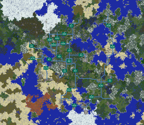
map by time2makemymove
Make your own road signs using these templates! (Note: Right-click the link, and select Save Link as...)


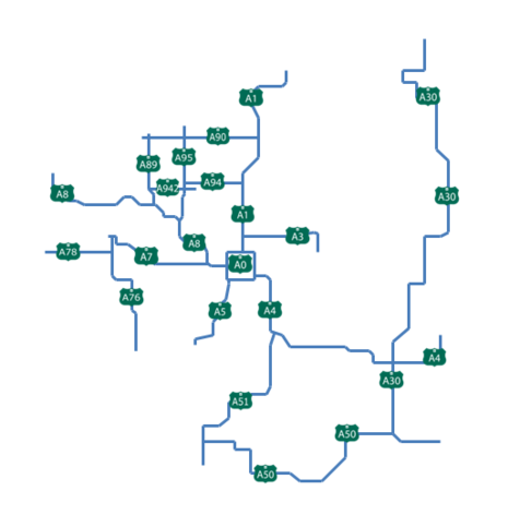
map by time2makemymove
A Class Highways
All players are welcomed to add planned or under construction highways, as well as updating the list to keep it up to date.
| Highways | Status | Information | Builder(s) | Termini | Map |
|---|---|---|---|---|---|
| Beltway around Central City | _frozen | Beltway | |||
| Connection between Central City and Nippia | CortesiRaccoon Narnia17 Gopher |
||||
| Connection between Seoland and Titsensaki | CodyHM | Seoland - Titsensaki | |||
| Motorway connection between Verdantium, and |
Mossie_, CaptainChimpy, designated Worker Corps | South Verdantium - |
|||
| Motorway connection between |
mainly Kel5, along with others | ||||
| Highway from |
AlphaDS | ||||
| A255 Nymphic Highway |
Connects Nymphalia and Padagonia, along with Windus Aura Airfield, to the A360 . | Melecie | A360 Nymphalia | ||
| An expressway entirely within Ravenna's city limits from an interchange with |
jphgolf4321 | Ravenna Mountainside International Airport |
|||
| A beltway around the Ravenna metropolitan area. | jphgolf4321 | N/A | |||
| Section between |
|||||
| Connection between |
CaptainChimpy | Ravenna - Wythern | |||
| Connection between Marblegate and Central City | |||||
| Connection between Pretoria and Ellerton Fosby | AP_Red Echohue kingsnake |
Pretoria - Ellerton Fosby | |||
| Open between Central City And Segville, Section to Delta City under Construction, Further south planned | Central City - Delta City - <Undefined> | ||||
UCWTIA Fwy |
Connection between |
Camelfantasy | |||
| Connection between Elecna Bay and Whiteley | |||||
| Connection between |
AP_Red | ||||
| Connection between |
time2makemymove | ||||
| Connection between Foresne Liveray and Devon | i____7d | Foresne - Devon | |||
| Connection between Central City And |
|||||
| Connection between |
Kangaroo567 woorich999 Echohue |
||||
| Connection between Ilirea and Central City | mikefishr | Ilirea - |
|||
| Connection between kolpino and Janghwa (Phase 1), |
|||||
| Connection between Ilirea and Kolpino City | mikefishr | Ilirea - Kolpino City | |||
| Connection between Ilirea and Wellington (only section between Ilirea and Savacaci open) | mikefishr | A76 south of Ilirea - Wellington | |||
| Connection between Central City and Spring Valley by way of Xilia and Whitechapel | Numerous Builders | ||||
| Extension from |
Ilirea - |
||||
| Connection between |
mikefishr | ||||
| Connection from |
_frozen Ardyle Soleurs |
Snowtopic - Whitechapel | |||
| Connection from |
Ardyle | Konawa - Armada | |||
| Connection between Vegeta, Chalxior and Oparia by way of Frostbite and Whitecliff | Numerous Builders | ||||
| Freeway running from |
jphgolf4321, Yellowitcher | ||||
| Connection from |
PtldKnight Earack | Konawa - Birchview | |||
Horizon Hwy |
Auxiliary route of |
Soleurs Earack _Kastle |
|||
| Freeway connecting Whitechapel to Laclede and |
jphgolf4321 | ||||
| Freeway connecting Laclede and Whitechapel with |
_frozen mikefishr jphgolf4321 Earack |
||||
| Freeway connecting |
Ardyle |


B-Class Highways
| Road | Status | Information | Planner | Builder(s) | Terminus 1 | Terminus 2 |
|---|---|---|---|---|---|---|
New Ambition Freeway |
Freeway-grade B road connecting Oparia to New Mackinaw. | EliteNeon, KyleFrb | EliteNeon, KyleFrb | New Mackinaw | ||
| The B road connecting Peripotamia to Bay Point. | Cookie46910, woorich999 | Cookie46910, _Kastle, woorich999, hvt2011 | Bay Point | Peripotamia | ||
York Highway 1 (York portion) |
Runs from New Mayton City to Mountains Pier. | Spegit007, Minecraft252 | Spegit007, Minecraft252, SimonScholar, Frumple, __Steve_n__ | New Mayton City (Continues as Rockaway Ave) | Mountains Pier | |
| Runs from |
jphgolf4321 | jphgolf4321, RedBear47, _MajorMagpie_ | ||||
| Runs from |
CodyHM | CodyHM, _HeavenAngel_ | The City of Seoland | |||
| The sister road to road |
_dubs17 | Earack, _dubs17, Soleurs | Armada | BirchView | ||
| From |
Earack | Earack | A90, Horizon National Airport | B17, Western Lanark | ||
| A B-class highway serving the Lower Zephyr North cities of Central City, Spruce Neck, Ashmore, and Mons Pratus. | Derpy_Melon, Skelezomperman | Derpy_Melon, _Kastle, Narnia17, MC_Protocol, Skelezomperman | Central City | Mons Pratus | ||
| An alternate route through the streets of Spruce Neck for |
Derpy_Melon, Skelezomperman | Derpy_Melon, Skelezomperman | ||||
| One of the two B-roads that will mainly be used to connect the |
Ben6331 | Ben6331 | Benion | Benion | ||
| The Farwater Skyway/Desert Shore Highway, a 4 lane road connecting Los Angeles to Ellesume via Farwater. It is an elevated controlled-access freeway from Los Angeles through Farwater's city center, and an at-grade 4 lane road through the desert and in Ellesume. | Diemundz, Allifarki | Diemundz | Los Angeles | Ellesume | ||
| The Altos Skyway, an elevated 4 lane freeway with an at-grade 2 lane road section that acts as an auxiliary loop for |
Diemundz | Diemundz | Figtree Street, Downtown Farwater | |||
| B-road from Mounty to |
Caillou15 AlphaDS |
Caillou15 AlphaDS |
Mounty | Lapis Bay | ||
| B-road that connects |
||||||
| B-road from |
Felix_An | Felix_An Grumpygoomba9 |
New Bakersville | |||
| Rodessa Avenue connecting |
AlphaDS | AlphaDS | Rodessa City | |||
| B-Road connecting the towns along the eastern end of the MRT Expo Line, from XE38 Foobar to Bawktown, with connections to |
FooteChicken imperial_block | FooteChicken, imperial_block, _O_OM3GA_O_, HenryRileyYT, Majatho3 | XE38 , |
Bawktown | ||
| B27 | Road connecting Beachview and Kappen. | ondist | ondist | Beachview | Kappen | |
Marina Highway |
Highway open between Marina and Merchant Interchange Merchant Interchange |
Tom_Pairs | Tom_Pairs, Technological99 | MRT Marina | ||
| B33 | Highway connecting Prismarine and Caravaca with the A54 | _Mossie | _Mossie | A54 | B34 Prismarine | |
| B333 Parkland Bypass |
Highway in operation between Parkland with Watford, as part of the first phase of the Parkland Bypass project. | STthecat | STthecat, MrMinecraft1423, Zuoj | B33 Watford |
Parkland | |
| The main regional throughfare for Accerton. | CaptainChimpy | CaptainChimpy | Accerton (planned |
|||
| B355S Cross Union of the North Eastern Jungle expressway (CUNEJE) |
A road connecting Jungleville and Midjungle. The road is one of the most important connections in the UNEJ. | Majatho3, imperial_block | Majatho3, imperial_block | Midjungle | Jungleville | |
| B355N | A road that connects Bawktown and Jungleville. It's essential for the transit from Jungleville to have a road to Bawktown, because there's a lot of connections to other Towns and Cities in Bawktown. | Majatho3, FooteChicken, imperial_block | Majatho3, FooteChicken, imperial_block | Jungleville | Bawktown | |
| A planned road to connect Newfounded by imperial_block and the town of North Bawktown by FooteChicken. | FooteChicken, Majatho3, imperial_block | FooteChicken, Majatho3, imperial_block,HenryRileyYT | North Bawktown | <XE38> and the A245/B246 | ||
| A road that connects Eastbourne to the |
OnyxCrow22 | OnyxCrow22 | Eastbourne | |||
| B337 | Road that connects Calgary to Valhalla. | Ludus, Spegit007 | Ludus, Spegit007,Frumple | Calgary | Valhalla | |
| A road that will run from Oceanside to the |
PaintedBlue, kingsnake | PaintedBlue, kingsnake | Oceanside | |||
| A road connecting Hensall and New Amsterdam. The road has a railway track down the middle, which is part of XenRail. | Vennefly, Red_Ray | Vennefly, Red_Ray | Hensall | New Amsterdam | ||
| B401 | A road connecting Siletz to the |
Unknown, ondist | Unknown, ondist | Siletz | Polytan Int'l Airport | |
| A road link that connects the city of Pearl Coast with the |
knowmads7 | (planned |
Pearl Coast | |||
| A road connecting Beaufort and Thunderbird. | Geobros429 Decorminecraft | Geobros429 Decorminecraft | Thunderbird | |||
| A short B-Class road between |
Wythern | |||||
| B42 | East New Brasil and Marisol | InfamousColumbia | InfamousColumbia | East New Brasil | Marisol | |
| Main throughfare in Scarborough to the |
sesese9 | camelfantasy, SuperBuilder400, Kel5 | Scarborough | |||
| A road connecting the |
ondist | ondist | B-Road between New Beginnings and A4 | Southport-sur-mer | ||
| Highway connecting the |
woorich999, ArizTrad | woorich999, ArizTrad | thrive | Sunshine Cove | ||
| Highway connecting Lakeview and Marblegate with Bronte and the |
Just_Robinho | Just_Robinho, Jian_Zen | Lakeview | Bronte | ||
| Connection between RV-4 in Rattlerville, Maricopa, and New Prubourne, Neverta in Meridia. | Spegit | Spegit, Kingsnake (Maricopa section) | Rattlerville Highway 4 in Rattlerville | New Prubourne | ||
| Partial ring road circling downtown New Prubourne | Spegit | Spegit | ||||
| Connection between Sycamore, Neverta and Rainer Bay. | Spegit | Spegit, several helpers | Sycamore | Rainer Bay via A440 (proposed) | ||
| Highway out of southern Formosa. FTA Ruby Line travels through the center. | Camelfantasy | Camelfantasy, RLcrafters, mjpwwf | Formosa | Danielston | ||
| A small highway that connects Conricsto to Matheson. | Conric005 | Conric005 | Conricsto | Matheson | ||
| SMP Freeway, serving all the districts within the proposed SMP of Sealane, Wallowyn and Formosa | RLcrafters | RLcrafters, Camelfantasy | Sealane |
|||
| All sections fully complete, enjoy the new road! | godzilltrain | RLcrafters, godzilltrain | Segville |
Sealane | ||
| B531 | Connection from Southoak to Peacopolis | i____7d | ktkren777, PeacemakerX5, i____7d | Southoak | Peacopolis | |
| Runs from |
time2makemymove | time2makemymove, jamess__ |
Near Downsview |
Paixton | ||
| Fully Finished. | Central City |
Segville | ||||
| An isolated, elevated, 4-lane B Road in the southwest Mesa biome between Deadbush and Totsworth. | MojangChan | MojangChan, Frosty_Creeper10 | Deadbush | Totsworth | ||
| A 4-lane B Road that serves to relieve traffic from Union Ave. | MojangChan | MojangChan, _Kastle | Deadbush | Valletta | ||
| B62 | 4-lane intercity road from Union Island to Chan Bay with a interchange at Jimbo | DoubR | ||||
| B65 | 2-lane intercity road running from Sansvikk to New Southport. Further extension planned to Villanueva. | Yellowitcher | Yellowitcher, luigi_board, unjinz | Sansvikk | New Southport | |
| Whiteley Quins Avenue | AP_Rednax | Whiteley | ||||
| B68 | Internal road in Kazeshima, will extend to Shahai | i____7d | i____7d | Kazeshima (Tamagoshima) | Kazeshima (Shakaishima) | |
| Link between |
lfpp003 | lfpp003 | ||||
| Kenthurst Northern Link (link between Kenthurst & |
Aliksong | Aliksong & Yellowitcher | Kenthurst | |||
| B717 | DesertView beltway | lfpp003 | lfpp003 | Beltway | Beltway | |
| 4 lane local expressway, linking Kenthurst to Ezzo City via Mississa Bay | ezzocraft, Aliksong | Aliksong, Leo_2807 | Ezzo City [E1] | Kenthurst Outer Ring Road | ||
| Link Between DesertView and B707 | lfpp003 | lfpp003 | B717 | |||
| Kenthurst Parkway | Aliksong | Aliksong & camelfantasy | Formosa |
Kenthurst | ||
| B74 | Kenthurst Eastern Link (link between Kenthurst and 42) | Aliksong | Aliksong | 42 | Kenthurst | |
| Highway linking Eisli, Espil to |
EspiDev | EspiDev | A5-W | |||
| Highway connecting Espil, Espil Ecilidae Airport, Aprix, Kolpino, Janghwa City, Pixl, and Xandar. | EspiDev | EspiDev, AlikSong & Seshpenguin | ||||
| B752 | Highway that runs through Pixl, connecting it to other highways. | Seshpenguin | Seshpenguin & Narnia17 | B751 | ||
| B753 | Highway connecting Espil, Espil Ecilidae Airport, Waverly and Pixl. | EspiDev | EspiDev & Seshpenguin | Waverly | B752 | |
| B754 | Highway connecting Cephyl, Espil to |
EspiDev | EspiDev | B751 | ||
| B755 | Highway connecting Evella to |
LDShadowLord | LDShadowLord | Evella | ||
| B756 | Highway connecting Falloway & Janghwa City to |
EspiDev | EspiDev | Falloway | ||
| Kenthurst Outer Ring Road, lovingly built by Aliksong. | Aliksong | Aliksong | ||||
| B82-2 | Road between Snowdin and Chillington. | CrazyRocketGuy | CrazyRocketGuy | Snowdin | Chillington | |
| Small road between Xilia and Watchfield. | Yellowitcher, the_blockmaster, powerminer01 | Yellowitcher and powerminer01 | Xilia |
Watchfield | ||
| B879 | Highway connecting Eagleshore to the |
TalonPlays, Kel5, Skelezomperman, United Cities | TalonPlays, Kel5 | Eagleshore | ||
| B89 | Formerly B82. Diagonal highway that transitions to a two lane country road. Between Armada and Snowdin. | CrazyRocketGuy, Ardyan | CrazyRocketGuy, Ardyan | Armada |
Snowdin | |
| Longest server's B-road. Runs parallel to the Taiga line from Formosa to Birch Forest City via Xilia, Cornus, Laclede, and Tetrapolis. Under construction between Formosa and Xilia. Extensions proposed to Janghwa M.C. and Furling | XW5 - M5 - D5 Formosa | C114 Birch Forest City | ||||
| Whitechapel |
Christi | |||||
| Links the Arctic Plains together, and with |
bensismith | bensismith, _Ptld | Freshney | West Calbar | ||
| Connects Pasadena with the A89 . | PtldKnight | PtldKnight | Pasadena | A89 | ||
| The Waterville Freeway: A Road Between the |
Yellowitcher PtldKnight | Yellowitcher, PtldKnight and Ardyan | ||||
| An Alternate Route of the B91 through the Streets of Pasadena to Orio via the Waterville Base Tunnel | Yellowitcher | Yellowitcher | ||||
| An Business Version of the B91 Through the Streets of Waterville's Downtown and Old Town. | PtldKnight | PtldKnight | ||||
| Road reorganizing as part of Armada Ringroad project. | Ardyle | Ardyle Yellowitcher |
Orio | Lancaster | ||
Alvingdale Highway |
A B-road connecting the village of Alvingdale with the A92 highway. May be the new longest B-Road on the server at the time of completion, surpassing the B90 by a big margin. | PaintedBlue | PaintedBlue, Crafterboi500 | Alvingdale | ||
| B93 | B-road connecting Quiris to Woodsdale | _HeavenAngel_ Toaro Hightech_TR |
Various | Quiris | Woodsdale | |
| Considered as an artwork rather than a functional road, it connects |
Ardyle | Ardyle | Spruce Plains | |||
| B94 | B-road connecting Quiris to Stoneedge | _HeavenAngel_ Soso123 |
_HeavenAngel_ | Quiris | Stoneedge | |
| Runs from |
jphgolf4321 | jphgolf4321, TakenName | ||||
| B944 | B-road connecting St. Albans to the A980 near town of Bechtel | HR0W | HR0W, BernCow | St. Albans | A980 near Bechtel | |
| Runs from Lanark to Spruce Hills. | Earack, Kenta1561 | Kenta1561 | Lanark Victoria Ave/Perimeter Road | Spruce Hills Southern Avenue |
Trivia
New World Highway System Road Scheme is based of the Great Britain road numbering scheme in real life. [1]