San Francisco
| San Francisco | |
|---|---|
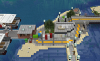
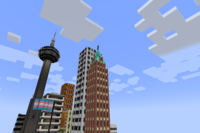
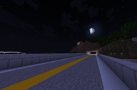
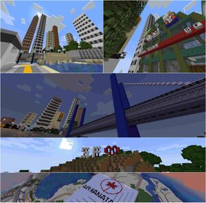 Clockwise from top: Downtown skyline from Rena Island, Market Mall SF, Bluelink Bridge, SF Heart Sign, Air Kanata Centre | |
| Officials | |
| Mayor | Spegit |
| Deputy Mayor | FooteChicken |
| Town recognition | |
| Rank | Governor |
| Date founded | August 30, 2022 |
| Date recognized as Councillor | September 10, 2022 |
| Date recognized as Mayor | October 3, 2022 |
| Date recognized as Senator | November 9, 2022 |
| Date recognized as Governor | January 11, 2023 |
| Geography | |
| Town hall coordinates | -19485 -25735 |
| World | New World |
| Ward(s) | Ward 9 |
| Transit | |
| MRT | WN60 San Francisco City Airport |
| Air facilities | San Francisco Midway International Airport Thomas Meunier San Francisco City Airport San Francisco Suroeste Island Heliport San Francisco Finn Waters Hospital Heliport |
| Rail facilities | West Zeta Rail Luz Rail |
| Local transit | SFMetro |
| Political affiliations | |
| State | Tierrente, Kanata |
| Lore | |
| Population | 95,000 (October 2022) |
San Francisco is a city in Tierrente, Kanata. It is named after the real life U.S. city of the same name. The mayor of San Francisco is Spegit. The city has roughly 90 buildings as of November 2022.
History
Founding and Councillor
On August 30th 2022, Spegit founded San Francisco on Rena Island, inspired by Sunshine Coast's Old Town island. She wanted to recreate the coastal city image like her past town Puerto Generico, abeit on the mainland and more North American.
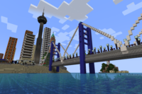
After completing Rena Island, Spegit moved on to the Downtown area, where she built the first building, a large brick skyscraper with a diamond top. She then made several more skyscrapers and began making the road network and what is now the northern section of the SFMetro C Line. On September 10th 2022, San Francisco got the rank of Councillor. She also made the SF Market Mall, and she filled the two spaces with her own franchises. After this she started laying out the framework for the Bluelink Bridge, which connects to the other side of the San Francisco Bay.
Mayor
After achieving Councillor, Spegit started developing the southern portion of Downtown, and also laid out the road network for the district of Bridgeview. On October 3rd, 2022, San Francisco achieved Mayor. The A Line was also extended to Bayfront (now Bridgeview) from York-Anderson station (now apart of the C Line). San Francisco Suroeste Island Heliport was built on Suroeste Island (Spanish: South-east island), named for its position to Downtown San Francisco. She also started work on the large Lynwood district, around the same time she achieved Conductor, which allowed her to landscape and build faster. When Lynwood and Bridgeview were both completed, she applyed for Senator.
Senator
San Francisco achieved the rank of Senator on Spegit's 15th birthday, November 9th, 2022 and she pasted in her schem that would become Thomas Meunier San Francisco City Airport. She also started work on Dalhousie, after the irl CTrain station she visited previously in October 2022. She continued to build with the goal to get to Governor. Over the coming weeks she developed Fairbank, Ridgewharf, and Nuukton.
Governor
San Francisco achieved the rank of Governor on January 11th, 2023, making the city the first city owned by Spegit to be the rank of Governor. Spegit pasted in the schem for San Francisco Midway International Airport, and opened gate requests.
Geography
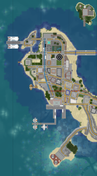
Downtown San Francisco sits on the San Francisco peninsula, a sandy and hilly peninsula on the northwest shores of the Eilean Sea. The surrounding area around the peninsula consists of oak forest, savanna plains, and plains biomes, where the majority of the city is. There are also several islands off the coast of the peninsula, such as Rena Island and Suroeste Island. There are also 3 artificial islands, Senido, Goose, and Duck, owned by some members after Spegit built them out of boredom.
Districts
Rena Island
The smallest district, it houses the City Hall.
The name comes from the longer name Bahian colonists gave the island in lore, Isla del círculo de arena, Spanish for Sand Circle Island.
Post code: SF9-101
Downtown
The largest district in the city, comprising of many skyscrapers. It is the main financial area of San Francisco.
Post code: SF9-102 and SF9-302
Suroeste Island
Suroeste Island (Spanish: Southeast island) is an island just southeast of Downtown, thus its name. It houses the San Francisco Suroeste Island Heliport.
Post code: SF9-303
Bridgeview
Post code: SF9-304 and SF9-404
Lynwood
The largest district in the town, it is a residential neighborhood. It has a 11-Seven and a strip mall.
Post code: SF9-205 and SF9-405
McMahon
A commercial district next to Lynwood, it has a C&W, a Koishi's Shrimp Fry, a Comet Cafe, and a Richville Metropolitan Bank.
Post code: SF9-206 and SF9-406
Ridgewharf
An industrial area, it houses the cargo port of the city, alongside a rail depot for Luz Rail trains.
Post code: SF9-407
Dalhousie
The second largest district, it has a mall area and a large park populated by many big hills called Inhill Park.
Post code: SF9-208
Fairbank
A small district, this neighborhood houses the Fairbank LRT Maintenance Facility for maintaining SFMetro LRT trains, Finn Waters Hospital, and the adjacent heliport.
Post code: SF9-209 and SF9-409
Airfield Beach
On the southern shores of the peninsula, it houses Thomas Meunier San Francisco City Airport and an Air Force Museum, and many franchises.
Post code: SF9-410
Tourism
Lodging
The Landmark
The Landmark is the city's oldest hotel, opening in 1932. It was renovated in 1974 when the Ontario Broadcasting Service (OBS) built their San Francisco flagship station, WSFD-DT. The hotel consists of 8 floors (above WSFD-DT) and has free Wi-Fi.
Eilian Beach Hotel
The Eilian Beach Hotel is a hotel on the wharf of the western beach of the peninsula. It has free Wi-Fi and was built in 1995.
Motor Motel
The Motor Motel is a small one storey hotel in Bridgeview. It has free Wi-Fi and opened in 1984.
Capri Inn Express
This Capri Inn Express hotel location is a 4 storey hotel in Airfield Beach, near San Francisco City Airport. It has free Wi-Fi and was built in 2008.
Attractions
SF Heart Sign
The SF Heart Sign is a national landmark and cultural icon that overlooks Southeast San Francisco.
Shopping
Market Mall SF
Opened in 1979, this mall helped to revitalize San Francisco's downtown core. It consists of a C&W and a 11-Seven.
Eilian Beach Strip Mall
Near the Eilian Beach Hotel, this mall consists of a Döner Plaza, a McYoshi Clone Emporium, and a San Francisco Style Pizza.
Lynwood Strip Mall
In Lynwood, this mall has a 1Bank, and many local businesses like Subway, Lynwood Dry Cleaning & Laundromat, Quagmire's Wine & Spirits, and Lynwood Computer Ltd.
Bridgewood Mall
On the border of Lynwood and Bridgeview, this mall is new and recently opened, with 2 spaces vacant, a Jack in the Box, and a Bristol Brew Coffee Company location.
Dalhousie Mall
In Dalhousie near Dalhousie SFMetro station, this mall has no franchises yet.
Transportation
Rail
SFMetro
SFMetro is the city's metro system operator. It operates 4 LRT lines, the A Line, C Line, and D Line. The B Line is under construction.
| Station | District | Connections | Status | Opened | Closed | Nearby Sights | Notes |
|---|---|---|---|---|---|---|---|
| Eilian-Bahia | Downtown | B Line | Planned | San Francisco Ferry Terminal | |||
| Desert-Bahia | Downtown | C Line | Open | ~September 2022 | San Francisco Ferry Terminal | ||
| Bridgeview | Bridgeview/Lynwood | Open | ~September 2022 | Originally opened as "Bayfront"
Half of station is in Lynwood | |||
| Lynwood | Lynwood | Open | September 30th, 2022 | Air Kanata Centre | |||
| McMahon | McMahon | Closed | ~October 2022 | November 27th, 2022 | Closed for being too close to Dalhousie | ||
| Dalhousie | Dalhousie | Open | October 22nd, 2022 | ||||
| Wimone | Fairbank | D Line | Open | November 5th, 2022 | Finn Waters Hospital
Fairbank LRT Maintenance Facility |
||
| East San Francisco | Fairbank/East San Francisco | Open | ~December 2022 | Half of the station is in East San Francisco, a separate city. |
| Station | District | Connections | Status | Opened | Nearby Sights | Notes |
|---|---|---|---|---|---|---|
| York-Rena | Downtown | B Line | Open (C Line) | September 5th, 2022 | City Hall, First Building in San Francisco | Originally opened as "North Point"
Originally an A Line station. Named "York-Metro Centre" until December 2022. |
| York-Anderson | Downtown | Open | September 7th, 2022 | San Francisco Tower | Originally an A Line station. | |
| Desert-Bahia | Downtown | A Line | Open | October 9th, 2022 | San Francisco Ferry Terminal |
| Station | District | Connections | Status | Opened | Nearby Sights | Notes |
|---|---|---|---|---|---|---|
| Wimone | Fairbank | A Line | Open | November 5th, 2022 | Finn Waters Hospital
Fairbank LRT Maintenance Facility |
|
| Airfield Beach | Airfield Beach | Open | November 17th, 2022 | San Francisco City Airport | Originally called "Aviation" for its location on Aviation Street. |
Luz Rail Commuter
Luz Rail Commuter operates a line from San Francisco-Union to San Francisco-Mayfair/Airfield Beach station currently. It has plans to extend further to future suburbs.
West Zeta Rail
West Zeta Rail's Pretzel Line terminates at San Francisco-Union and has a separate line, the Tierrentian Express, that goes between Los Corozos and San Francisco City Airport.
Road
San Francisco Freeway
The San Francisco Freeway is a short highway that stretches the entire length of the city at around 1 kilometer. It was built over two months from September to October 2022. A video was published by Spegit on YouTube tours the highway, officially signed as Tierrente Route 1. The video can be found at this link: https://www.youtube.com/watch?v=MrDR4Vx-inU&t=11s .
Air
Airplane
Thomas Meunier San Francisco City Airport is an airfield in Airfield Beach, just east of Ridgewharf and south of Fairbank and Dalhousie. It is connected to the SFMetro by Airfield Beach station on the D Line. Upon reaching the rank of Governor in January 2023, Spegit built a new airport for the city, San Francisco Midway International Airport, named for Chicago's airport in real life, as she liked the name. It has 40 gates and is a hub for Continental Airlines and Air Kanata.
Helicopter
San Francisco Suroeste Island Heliport is a heliport just southeast of Downtown. It was the first air facility built in the town. San Francisco Finn Waters Hospital Heliport was constructed in February 2023 after Spegit had leftover Governor allocations. It has 3 gates and is located next to the hospital of the same name.
Bus
San Francisco Air Express
The San Francisco Air Express is a special bus route operated by SFMetro that runs in San Francisco between major air facilities in the city.
| Stop | Notes |
|---|---|
| Thomas Meunier San Francisco City Airport (Bus terminal) | |
| San Francisco Finn Waters Hospital Heliport | |
| San Francisco Union Station (West Zeta Rail and Luz Rail) | |
| San Francisco Suroeste Island Heliport | The heliport is across the bridge. |
Culture
Cuisine
San Francisco has a diverse cuisine inspired by many places around the MRT because of the city's high immigrant rate and diversity.
Languages
San Francisco's official language is English, however Spanish is a recognized language, being spoken by 40% of the city's population.
Sports
| Club | League | Venue | Established | Championships |
|---|---|---|---|---|
| San Francisco Sharks | Major League Spleef | Air Kanata Centre | 2023, 1907 in lore | 0 |
Public Services
Education
| Status | Name | Type | Grade | District | Laungauge |
|---|---|---|---|---|---|
| Open | Market Lawn School | Public | 1-2 | Downtown | English |
| Open | Jose Ronaldo Middle School | Public | 5-8 | Lynwood | English |
| Under Construction | Lynwood Elementary School | Public | K-4 | Lynwood | English |
| Open | Heart High School | Public | 9-12 | Lynwood | English |
Location
San Francisco is located around 2 kilometres north of Singaport, around 300 metres south of San Ostend, and 4 kilometres northeast of Las Playas. It is in the Kanatian state of Tierrente.
