Talk:A28
This page is for people who are involved with the planning of the highway of A28 and people who's towns co-inside with it.
I plan on sending the proposal for the A28 by the next GSM. Allifarki (talk) 07:36, 31 December 2015 (EST)
The Republic of Woodsdale hereby approve the B160 Branch Road off the A28 to Woodsdale, awaiting approval from allifarki. -- Hightech_TR (talk) -- 16:13, 4th January 2016 (SGT/ACT) (GMT/UTC+8)
Approved Allifarki (talk) 03:31, 2 January 2016 (EST)
UPDATE
Hey guys, I have found a good style off a video on YouTube for A28. Link = [1]
Current Map Status - 30th Dec 2015

My only question is: do you have perms yet from these mayors? Sesese9 (talk) 12:28, 30 December 2015 (EST)
Sesese: I have perms for most. I just need perms from Yoshi, Major and GeneralJaybird
Alli: I got perms for the A30 from Yoshi, AND I told him about A28. He was fine with it, and told me to re-establish contact when we get near. I have also contacted TomP, who's the new owner of Redloch, as he's developing his town towards our planned route. Chimpeh - Gimmeh da bananas now! :D (talk) 13:35, 30 December 2015 (EST)
Ok thanks Chimpy --Allifarki (talk) 07:33, 31 December 2015 (EST)
Route alignment
Keep in mind that the area between Huntington and Redloch has already been preplanned, as the A28 shares the same road with the A30. Chimpeh - Gimmeh da bananas now! :D (talk) 12:35, 30 December 2015 (EST)
Ok, we will need to do some planning about that. Allifarki (talk) 07:34, 31 December 2015 (EST)

Made a cleaner map with the A30 as well. I'll leave exits to you ;) Chimpeh - Gimmeh da bananas now! :D (talk) 11:00, 31 December 2015 (EST)
Thanks Chimpy, I might use that map for the proposal Allifarki (talk) 12:35, 31 December 2015 (EST)
MC_Dunc is building a highway near Birchview. You should use it. Yellowchamallow (talk) 19:46, 1 January 2016 (EST)
Ok, thanks for telling me I will contact MC_Dunc as soon as possible. Allifarki (talk) 01:52, 2 January 2016 (EST)
Having A30 and A28 split around Ellesume and those other undeveloped stations seems a bit unnecessary as of yet. Would you maybe consider having the A28 terminate at A30 near the Hummingbird Isles and instead have A30 run somewhere between the two proposed alignments? jphgolf4321 (talk) 14:26, 11 January 2016 (EST)
- Good point. I believed the reason was to encourage further development around Ellesume, also as a loop so that it can be connected. However the Ellesume Bypass could be designated a B-road. Chimpeh - Gimmeh da bananas now! :D (talk) 14:34, 11 January 2016 (EST)
Too late to change plans, I'm sending the proposal Allifarki (talk) 13:10, 13 January 2016 (EST)
A28 Logs
1st Jan 2016
Building starts on templates and test designs.
10th Jan 2016
Junctions plan complete:
| Status | Exit number | Destinations | Road designation | Notes |
|---|---|---|---|---|
| 1 | A30 (planned) | |||
| 2 | Florensia (planned) | |||
| 3 | Wincanton - B20 (planned) | |||
| 4 | Ellesume - LH-1 (planned) | |||
| 5 | Lopaia (planned) | |||
| 6 | North Haven - A30 (planned) | |||
| 7 | North Haven - Mason City (planned) | |||
| 8 | Mason City (planned) | |||
| 9 | Conrondo - Huntingdon (planned) | |||
| 10 | C8 Foobar (planned) | |||
| 11 | C4 New Phoenix North - New Phoenix (planned) | |||
| 12 | Danedanong East (planned) | |||
| 13 | Danedanong (planned) | |||
| 14 | Birchview - East (planned) | |||
| 15 | Birchview - North (planned) | |||
| 16 | Birchview - West (planned) | |||
| 17 | Birchview - A1 (planned) | |||
| 18 | Woodsdale - B160 (planned) | |||
| 19 | Gold City - East (planned) | |||
| 20 | Gold City - North (planned) | |||
| 21 | Birch Forest City - North (planned) | |||
| 22 | Birch Forest City - West (planned) | |||
| 23 | Konawa - North (planned) | |||
| 24 | Armada - Quasar East (planned) | |||
| 25 | Armada - Quasar Centre (planned) | |||
| 26 | Armada - Quasar West (planned) | |||
| 27 | Armada - Cross (Future E/W/T station) (planned) | |||
| 28 | Armada - City (planned) | |||
| 29 | Armada - A89 (planned) |
Phase 2 will start from here but shall be covered in a future proposal
Comments from the A30 Group
First, there is no chance there will be J9 due to space. The area around the bit where the tunnel turns to bridge is reserved for the rail deposition compound (coz remember, there are railways on the lower level).
However I have worked out a counter proposal: Combine J7 into a central interchange and a short B-road connecting Mason City and North Haven. J6 will be a Nth Haven junction only, and 8 will be a Mason City only junction.
Second, J10 & 11 should be merged together for greater efficiency. Also this merger will allow for a spur setup where the Coronado junction can branch off.
Third, Junctions 6 to 11 are merged in with the A30.
Fourth, the A30 will have different junction identifiers to the A28, therefore a different signage format and style will be used.
Fifth, the Group is considering sending the Northern proposal in Feb/March. I would suggest perhaps working on Phase 3 of the above map last.
Please let me know what you think of my comments. Thanks!
Chimpeh - Gimmeh da bananas now! :D (talk) 12:31, 10 January 2016 (EST)
Ok, can you please show me what you mean then finish the map so I can use it on the proposal. We've only got another 5 days. Allifarki (talk) 02:55, 11 January 2016 (EST)
- Sorry alli. I can't get on this weekend. But I'll try getting it to you. Why don't you send it to me, but a few clarifications are needed per the junctions? Chimpeh - Gimmeh da bananas now! :D (talk) 13:27, 11 January 2016 (EST)
I has plan. Hopefully it'll work. Allifarki (talk) 02:17, 12 January 2016 (EST)
12 Jan 2016
Almost there, proposal probably going to be sent on Friday and I've got the FULL VERSION of the map ready for the proposal. It's below, my mouse was messing up at the time so the junction dots are a bit messy.

- Ok, I'm fine with 2 exits around Mason and Nth Haven - however the one on the left is space permitting. Chimpeh - Gimmeh da bananas now! :D (talk) 13:54, 12 January 2016 (EST)
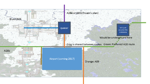
Armada exits
Hi, I might sound selfish here but having the road go from Quasar Tunnel is not needed right now. I'll prepare a map to explain the situation.
--_Ardy - THIS SIGNATURE IS SPONSORED BY VANADIUM SYSTEMS (talk) 12:01, 12 January 2016 (EST)
- Edit: My suggestion pretty much requires replanning basically all of Phase 1, I'll do that as well --_Ardy - THIS SIGNATURE IS SPONSORED BY VANADIUM SYSTEMS (talk) 12:43, 12 January 2016 (EST)
::::::
Tell me if these could work, and if they don't, tell me your suggestions as well so I'll work out one that fits the original proposals--_Ardy - THIS SIGNATURE IS SPONSORED BY VANADIUM SYSTEMS (talk) 12:53, 12 January 2016 (EST)


Ardy, I eventally plan to submit a proposal to build the A28a and A28b with a going to Wazimawazi and b going to Snowtopic, that shall probably change your plans. Allifarki (talk) 13:15, 12 January 2016 (EST)
Also I must build the A28 coming on the northeast side of Armada due to the fact I cannot build through the center of Konawa. Allifarki (talk) 13:15, 12 January 2016 (EST)
- Why can't you just go around the center of Konawa and curve the road in the direction of the southeast of Armada.jphgolf4321 (talk) 14:20, 12 January 2016 (EST)
- Actually still completely possible with my plan, of course with jp's suggestion as well. lemme just scheme it up and it'll be there_Ardy - THIS SIGNATURE IS SPONSORED BY VANADIUM SYSTEMS (talk) 15:36, 12 January 2016 (EST) :::
- Actually still completely possible with my plan, of course with jp's suggestion as well. lemme just scheme it up and it'll be there_Ardy - THIS SIGNATURE IS SPONSORED BY VANADIUM SYSTEMS (talk) 15:36, 12 January 2016 (EST) :::

I was told by the mayor to keep at least 350-250 blocks from Konawa Allifarki (talk) 12:15, 13 January 2016 (EST)
- Then what about having the road do the turn somewhere in between Birch Forest and Konawa and have exits at southern part of Konawa? I know it's a pain to contact soleurs outside MRT, but I call try to do so using Skype if you think that would work--_Ardy - THIS SIGNATURE IS SPONSORED BY VANADIUM SYSTEMS (talk) 12:36, 13 January 2016 (EST)
Any and all denials of A and B-class roads near Konawa are rescinded, but please talk to me about how you want the road to go through or near the town!! (Soleurs) (talk) 01:31, 06 March 2016 (CST)
Making the Actual Wiki Page
I think this may be the only talk page on the whole wiki that doesn't have an actual page to talk about. jphgolf4321 (talk) 13:14, 13 January 2016 (EST)
A28 Proposal
In the January GSM, the A28 was rejected. See how the route is quite long and follows the northern semicircle of the circle line. Hightech_TR (talk)
I only had 12 mins to write it. Allifarki (talk) 02:44, 17 January 2016 (EST)
A91(90) - Planning has started
Planning will be finalized by this May, so far here's what I have. I don't plan to serve Woodsdale directly, but a B road branching off would be nice.
| Status | Exit number | Destinations | Road designation | Notes |
|---|---|---|---|---|
| 23 | Armada - Airport (planned) | A89 | ||
| 23 | Konawa (planned) | |||
| 23 | Lanark (planned) | Not eligible for a road, but gave perms | ||
| 23 | Birch Forest City (planned) | Perms not received | ||
| 23 | Gold City (planned) | Perms not received | ||
| 23 | Birchview (planned) | A1 Perms not received |
- What I would suggest is it being called the A90 to fit the big server ring road network I'm trying to implement, eg, the A50 and the A30
Is that the new A28? Cool. I'd suggest a branch to Woodsdale and Birchview Leydon. And I agree you should name it A90. -Yellow
Id Say it should Stay as A91 and I will propose it. All I need to do is make plans as I thought of this idea back in January ~Ptld
True, though I would say that I would like to do the proposal. Though, you'll get credit. I'll also consider renaming to A90. --Ardyan - director of stupid and pointless since 2016 (talk) 16:20, 6 March 2016 (EST)
A28 PLANNERS AND OTHER STUFF THE A28 ALTERNATIVE PROJECT (A222)'S PLANNING HAS BEGUN: A222 --Allifarki (talk) 04:03, 2 April 2016 (EDT)