West Ocean Partnership
| West Ocean Partnership | |
|---|---|
 Official Flag | |
| Officials | |
| Founders | thomasfyfe BaronThamesBank cal76 |
| Information | |
| Founded | October 13, 2014 (privately) January 12, 2016 (publicly) |
| Headquarters | C78 Daneburg (under construction) |
| Membership | 7 Towns/Cities |
The West Ocean Partnership (WOP) is an alliance of towns of cities located around the New World's West Ocean, within Ward 6 and Ward 7. It was founded by staff members thomasfyfe, BaronThamesBank and cal76 around the time of the New World launch for their cities of Falloway, Daneburg and Waverly. It was officially recognised in January 2016 when it opened up membership to qualifying players.
The main purpose of the West Ocean Partnership is to allow planning and collaboration between towns, specifically regarding rails and roads. The partnership can also be used to inform other players in the region of city plans and expansions. Overall, this will ensure a more informed, and enjoyable building experience on the server.
Unlike other Metropolitan Planning Organizations, WOP does not hold elections or vote on resolutions. Instead, the West Ocean Partnership is intended to be an information sharing platform. Discussions on city plans, expansions and border suggestions can be found on the Discussion page.
West Ocean Partnership Member Cities
| City | Station | Mayor | Rank |
|---|---|---|---|
| Daneburg | C78 | BaronThamesBank | Senator |
| Espil | C80 - C81 | _InDev_ | Premier |
| Falloway | C76 | thomasfyfe | Governor |
| Heampstead | M42 | MikeRoma | Senator |
| Helix Bay | C77 | TrainPro | Councillor |
| Pamsterlin | C75 | leeuweb | Councillor |
| Waverly | C79 | cal76 | Mayor |
Membership
The West Ocean Partnership is open to join for any town/city that meets the following requirements:
- Located around the West Ocean on the New World.
- Town has achieved the rank of Councillor or higher.
To join, leave a message on the Discussion page.
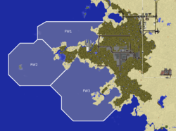
The West Ocean Naval Alliance is a suborganisation that helps to players to define maritime boundaries as well as share information on maritime activity such as boat locations and coastal builds. A map and system to allow players to contribute to this is in the works.
Falloway is the only city in the West Ocean Partnership so far to have defined maritime boundaries.
Please note, maritime boundaries are suggestions only and are not recognised officially by the server. Their use is to give other members of the West Ocean Partnership a suggestion of where to build within the West Ocean. Boundaries can be suggested and contested on the Discussion page.

