User:Chiefbozx/Road signs
DISCLAIMER: This is a proposed standardization, please discuss on discussion board or Google Groups.
Classification of Roads
Roads will be classified into one of three types, depending on where they are:
- "A" roads are dual carriageways, like I-0. They travel long distances and have separated areas for the two directions of traffic.
- "B" roads are single carriageways, like the G23 highway connecting B13 G14 Y15 R7 Spawn to G23 Manangatang, G25 Chargestone-Kipener and O21 Eisitasi.
- "C" roads are major inner-city roadways, like Main Street in Spawn or Fairfax Avenue.
There are no "D" roads, and not all roads are classified.
Signage
Identification of Roads
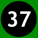
Classified roads are identified with their classification, followed by their map number and route number. For example, road 37 of classification A on the old map is identified as A137. Its identification marker is shown on the left. The identification marker remains the same across maps, so roads A100 and A200 share the same actual map file. This is to save on disk space.
Maps for roads X00-X09 only show the last digit. So even though you just see a zero in a black circle... you're on A100, A200, etc. It will be rather obvious what map you're in.
Road numbers are three digits in length, with an optional auxiliary suffix at the end. Road numbers may be from X00 to X99 inclusive, where X is the "map number": the original map (2012-2014) roads, if switched, use number 1, and new map (starting in 2014) uses 2. So the current I-0 would become A100, and I-100 would likely become A100-S as it serves Spawn City. When numbering a road, odd numbers (ending in 1, 3, 5, 7 or 9) are used for north-south routes, and even numbers (ending in 0, 2, 4, 6 or 8) are used for east-west routes. Unlike the US Interstate Highway System, we won't make an attempt to organize road numbers, since new roads can pop up at any time.
Auxiliary suffixes are single letters. Yes, this goes against the US Interstate Highway System, but it means it's about 2,600 fewer maps. These are added onto the end of a road number - so the U spur of road A137 would be identified as A137-U (note the dash). These suffixes are used for spurs (has one terminus at the main road), loops (has both termini at the main road), and bypasses (express segments that bypass a city, they are also loops), but there's no restriction on what letters can be used. It's totally cool for A109-C to be a loop and A257-C to be a spur. The only restriction is that each main road can only use the same suffix once. Common suffixes are U for University, W for Waterfront, D for Downtown, X for Express, B for Business, or A for Airport.
To pronounce a road number, it is read (classification) (map code) (route number) (suffix), so A101-Z would be read "A One Oh-One Z". The road "A100" can be read as "A One Hundred".
Auxiliary suffixes follow the same pattern for their signs as the main roads, except the letter is in a rounded rectangle. (A road suffixes are black rounded rectangles, B are white with a black border, and C are all white).
