Autobus Train Transport System
Welcome to the Autobus Train Transport System (ATTS) company.
| ATTS Stock | ||||||||
|---|---|---|---|---|---|---|---|---|
|
What We do
We make subway and aboveground train systems with the newest technology, simple to use station designs, light rail systems, trams and lots more!
Getting Our Transport System
It must be far-off spawn otherwise autobus22 can't build because of computer lag.
We offer:
- 3 Transport systems: Tram, Light-Train, Subway/Train.
- Only Trams
- Only Light-Train
- 2 Transport Systems: Tram and Light-Train
- Only Train (can only be ordered if Trams and Light-Rails aren't possible in a city)
We Offer
Tram Simple transit system with simple stations. Tram tracks are mostly laid on roads and the tram stops are designed closely the player who orders the system. Furthermore, you may choose to have overhead wires if your city/town is not too hilly. It will stop around every 40 blocks.
Light-Train Simple transit system for longer distances with bigger stations that offer more waiting space and comfort for the traveller. Uses very simple departure systems and stations are mostly found around every 100-200 blocks.
Light-Train Subway Same as the Light Train but located underground.
Train Advanced redstone for easy use with completely automatic stations for long distance travels. More waiting space and safe minecart departure. Stations are mostly around 500 blocks away from each other. (can also be ordered as Subway variant)
Autocity Transit Lines
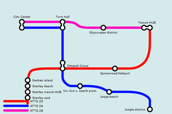
Train 25 ATTS
| Autobus Train Transport System | |
|---|---|
| 25 | |
| Route | Autocity to Omerah via Autocity Island and Bensi Shore |
| Number of stations | 10 (4 planned/construction) |
| Status | Complete |
| Players involved | |
| Main builder | autobus22 |
| Additional builders | bensismith and EchoMiner99 |
| Technology | |
| Station | AIBCSTSSS V 1.0 and AISCS V 0.6.7 and ASACSSLT |
| Track | ATTS Stand3 Iron and stun76 |
This is the subway line which ATTS started with first. This subway was going to be the first way to travel out of Autocity with subway and bus connection to Omerah and onward to various subways that stop there. When the line was finally opened it was 2 months later and Autocity already had 2 bus lines going out of the city and this line was no longer the first transit out of autocity.
On 31 December 2013, there were plans to change the end of the route to City Center instead of Omerah Cross. Until this part of the line was finished, only the section between Omerah and Autocity Omerah Cross was open. On 11 January 2014, the plans to connect to the City Center where dropped due to the fact that there was restricted space in the city center. On the same day, Cortesi's former island became the property of autobus22 and Bensismith. The ATTS 25 Line was then extended to this location.
The new section to the island was opened two days later on 13 January 2014.
| Status | Code | Station name | Connections |
|---|---|---|---|
| 25 | Omerah Marina (under construction) | Omerah tram, ATTS 32 | |
| 25 | Omerah Transit Hub | OIM QIR1 JD-R1 900 | |
| 25 | Omerah Hotel | None | |
| 25 | Omerah Smith Shore | None | |
| 25 | Stanley South | None | |
| 25 | Stanley Transit Hub | Stanley Transit | |
| 25 | Stanley Beach | Stanley Transit | |
| 25 | Omerah Sunken Island | None | |
| 25 | Autocity-Omerah Cross | 26 28 900 | |
| 25 | Autocity Quinnsroad | None | |
| 25 | Autocity Transit Hub | Multiple rail and bus lines. For full connections see here. | |
| 25 | Magentine Town Hall (under construction) | None | |
| 25 | Magentine East (planned) | None | |
| 25 | Gund Valley (planned) | Need Perms |
Train 26 ATTS
| Autobus Train Transport System | |
|---|---|
| 26 | |
| Route | Autocity Internal Line: City Center to Jungle District |
| Number of stations | 6 |
| Status | Complete |
| Players involved | |
| Main builder | autobus22 |
| Technology | |
| Station | ATTS Rockstone LT Simple V1.0 |
| Track | ATTS Stand2 Underground |
This is the second subway line from ATTS. This line is located in Autocity and connects all of the beach districts to the South of the city center. The line was originally designed as a transport link between the town hall and the redstone lab via the beach promenade.
Later on the decision was made that a subway to the redstone lab wasn't needed.
But with Autocity's expansion the Red (25) line opened a station on the edge of the city so to connect to the town hall. A day later, a decision was made so that there must be a central transport center in the middle of the city to connect as much of the city's transport together.
This would lead to a quicker journey for travellers. The line's proposed route then became: Autocity City Center - Autocity Town Hall - Autocity Beach Promenade - Autocity-Omerah Cross (with connections to the ATTS 25 Line). Unfortunately due to construction work struggling with large cave systems underground the Autocity Beach Promenade station was removed from the proposal and the line went ahead with the remaining three stations.
On 31 December 2013, plans were made to expand the line to the new Kiwi Beach District. This brought the line's route service to: Autocity City Center - Autocity Town Hall - Autocity-Omerah Cross - Autocity Kiwi Beach District. On 13 January 2014, reconstruction work began on the City Center and the line was temporarily closed. On 30 January 2014, the line re-opened between the City Center and Omerah Cross and players could now transfer to the first other ATTS 25 line at Omerah.
| Status | Code | Station name | Connections |
|---|---|---|---|
| 26 | Autocity City Center | 27 28 29 | |
| 26 | Autocity Town hall | 28 | |
| 26 | Autocity-Omerah Cross | 25 900 | |
| 26 | Autocity Kiwi Beach district | None | |
| 26 | Autocity Jungle Beach | None | |
| 26 | Autocity Jungle District | None |
Train 27 ATTS
The idea for this line was made in early November 2013 but planning work only began on 31 December 2013. On 13 Jan 2013 the line's plans were overhauled and it was decided that the line will connect the City Center with the new Automountain lookout tower that had recently started construction. The ATTS team is planning to start building this line by the end of 2014. Mid 2014 route is changed to serve the newly build wipeout course for MRT Wipeout.
| Status | Code | Station name | Connections |
|---|---|---|---|
| 27 | Autocity City Center (planned) | 26 28 29 | |
| 27 | MRT wipeout (planned) | None |
Train 28 ATTS
| Status | Code | Station name | Connections |
|---|---|---|---|
| 28 | Autocity City Center | 26 27 29 | |
| 28 | Autocity Town Hall | 26 | |
| 28 | Autocity Skyscraper District | None | |
| 28 | Autocity Transit Hub | Multiple rail and bus lines. For full connections see here. |
Train 29 ATTS
The ATTS team is planning to start building this line in June 2014.
| Status | Code | Station name | Connections |
|---|---|---|---|
| 29 | Autocity City Center | 26 27 28 | |
| 29 | Autocity ABS tech Labs (planned) | None | |
| 29 | Autocity Mario Kart Courses (planned) | None |
Omerah Transit Lines
Train 30 ATTS
| Status | Code | Station name | Connections |
|---|---|---|---|
| 30 | Omerah Docks | Omerah Tram | |
| 30 | Omerah Marina | Omerah Tram | |
| 30 | Omerah Boats | None |
Riverend Transit lines
ATTST Magenta Tram
This Tram line was designed to connect the transit center with the government district and a new district with houses on the east of Riverend. The line officially opened on 15 January 2014.
| Status | Code | Station name | Connections |
|---|---|---|---|
| TM01 | Riverend City Center | MRT Orange line IB07 ABS 996 Riverend Tram | |
| TM02 | Riverend Police Office | None | |
| TM03 | Riverend Cal's Mansion | None | |
| TM04 | Riverend City Hall | None | |
| TM06.6 | Riverend Country Parliment | None | |
| TM07 | Riverend Southern Houses | None | |
| TM08 | Riverend South street | None | |
| TM06.7 | Riverend Evergreen DV | None |
ATTST Cyan Tram
This tram is designed to connect the transit hub with the old town and the market district. It also crosses station Barnsley. The line officially opened on 16 January 2014.
| Status | Code | Station name | Connections |
|---|---|---|---|
| TC01 | Riverend City Center | MRT Orange line IB07 ABS 996 Riverend Tram A | |
| TC02 | Riverend Park and Ride | None | |
| TC03 | Riverend Barnsley | A | |
| TC04 | Riverend Old Town Hall | None | |
| TC05 | Riverend Harbour | None | |
| TC06 | Riverend Cozy Cafe | None | |
| TC07 | Riverend Station South | A | |
| TC08 | Riverend fire departement | None | |
| TC09 | Riverend Cal tower | None |
ATTST Yellow Tram
This tram is designed to connect the transit hub with main street. The Line officially opened on 17 January 2014. It got reroutened on 27 jun 2014 to not end on cal tower via foobarstreet but end on National sign park via Main street.
| Status | Code | Station name | Connections |
|---|---|---|---|
| TY01 | Riverend City Center | MRT Orange line IB07 ABS 996 Riverend Tram | |
| TY02 | Riverend Grand Park | None | |
| TY03 | Riverend Jewler | None | |
| TY04 | Riverend Toll Booth | None | |
| TY05 | Riverend Tower | None | |
| TY06 | Riverend Post Office | None | |
| TY07 | Riverend Galactic Studios | None | |
| TY10 | Riverend Main street | None | |
| TY11 | Riverend National Sign Park | None |
ATTST Green Tram
This tram connects farrgut north with riverend and also connects the new library and the industrial district. Opened on: 18 Jan 2014
| Status | Code | Station name | Connections |
|---|---|---|---|
| TG01 | Riverend City Center | MRT Orange line IB07 ABS 996 Riverend Tram | |
| TG02 | Riverend Train HUB | MRT Orange line | |
| TG03 | Riverend Glass Fabrik | None | |
| TG04 | Riverend Dave's Fabrik | None | |
| TG05 | Riverend Residental | None | |
| TG06 | Riverend Old street/Courthouse | None | |
| TG07 | Riverend Library | None | |
| TG08 | Riverend West street | None | |
| TG09 | Riverend Riverend Bypass | None | |
| TG11 | Farrgut North Lee Highway | None | |
| TG10 | Farrgut North | None |
ATTS International
Metro A
In construction, Perms granted for all stations
| Status | Code | Name | Exchange with other RaiLinQ lines: |
|---|---|---|---|
| A09 | Riverend south | Riverend tram | |
| A10 | Barnsley | Riverend tram | |
| A11 | Riverend | to many to count | |
| A12 | Nopado City Center | No connections | |
| A19 | Houghton North (under construction) | No connections | |
| A13 | autotown/o5 (under construction) | No connections | |
| A15 | autotown Riverbeach (planned) | No connections | |
| A16 | Palmville/I700 (closed) | No connections |
Stanley transit
Tram
| Status | Code | Station name | Connections |
|---|---|---|---|
| ASGT1 | Stanley hub | ATTS 25 and stanley transit lines | |
| ASGT2 | Stanley town hall | None | |
| ASGT3 | Stanley ASGT HQ | None | |
| ASGT4 | Stanley stanleypath | None |
Red Line: Metro 1
| Status | Code | Station name | Connections |
|---|---|---|---|
| ASGTM1.1 | Stanley hub | ATTS 25 and stanley transit lines | |
| ASGTM1.2 | Stanley HeliPort | None | |
| ASGTM1.3 | Stanley Harbour | None |
Orange Line: Metro 2
| Status | Code | Station name | Connections |
|---|---|---|---|
| ASGTM2.1 | Stanley Residental District | None | |
| ASGTM2.3 | Stanley HeliPort | None | |
| ASGTM2.2 | Stanley hub (under construction) | ATTS 25 and stanley transit lines | |
| ASGTM2.4 | Stanley Town Hall (under construction) | tram | |
| ASGTM2.6 | Stanley Busstation (planned) | None |
Houghton and Autotown Transit
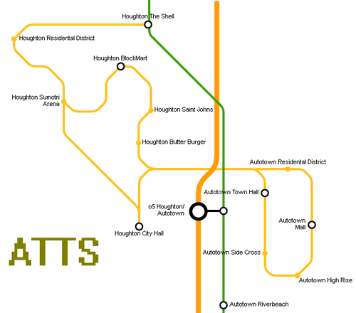
Tram O5 Line
| Status | Code | Station name | Connections |
|---|---|---|---|
| 5 | Houghton The Shell | None | |
| 5 | Houghton Residental District | None | |
| 5 | Houghton Sumotori Arena | None | |
| 5 | Houghton City Hall | None | |
| 5 | Autotown Town Hall | None | |
| 5 | Autotown Side Cross | None | |
| 5 | Autotown High Rise Building | None | |
| 5 | Autotown Mall | None | |
| 5 | Autotown Residental District | None | |
| 5 | Houghton ButterBurger | None | |
| 5 | Houghton Saint Johns | None | |
| 5 | Houghton BlockMart | None | |
| 5 | Houghton Sumotori Arena | None | |
| 5 | Houghton Residental District | None | |
| 5 | Houghton The Shell | None |
Shadowrock subways
Green line (61)
| Status | Code | Station name | Connections |
|---|---|---|---|
| 61 | Shadowrock Hotel | None | |
| 61 | Shadowrock Transit HUB | MRT BLUE,ATTS 62 | |
| 61 | Shadowrock Swimming pool | ATTS 62 | |
| 61 | Shadowrock PigParking | ATTS 65 | |
| 61 | Shadowrock Jr. Highschool (under construction) | None | |
| 61 | Shadowrock Local Pub (under construction) | None |
red line (62)
| Status | Code | Station name | Connections |
|---|---|---|---|
| 62 | Shadowrock Chalet Street | None | |
| 62 | Shadowrock Sacred Chapel | None | |
| 62 | Shadowrock Transit HUB | MRT BLUE,ATTS 61 | |
| 62 | Shadowrock Swimming pool | ATTS 61 | |
| 62 | Shadowrock Well | Arrowhead line | |
| 62 | Shadowrock Dance studio | None |
Blue line (65)
| Status | Code | Station name | Connections |
|---|---|---|---|
| 65 | Shadowrock Town Hall (under construction) | None | |
| 65 | Shadowrock PigParking | ATTS 61 | |
| 65 | Shadow's Cabin's (under construction) | None | |
| 65 | Shadowrock Amphitheatre (under construction) | None |
SCL
I colaborate with SCL with the spawn city link E line:
| Status | Code | Station name | Connections |
|---|---|---|---|
| E | Trusted tower (under construction) | TBA | |
| E | Central (under construction) | TBA | |
| E | Admod (under construction) | TBA | |
| E | Spawn City Park (under construction) | TBA |


