Port Authority of New Bakersville
| Port Authority of New Bakersville (PANB) | |
 Current logo | |
| Formation | 4, 30, 1904 |
|---|---|
| Type | Port district |
| Headquarters | 2 Rockefeller Center, Downtown, New Bakersville |
| Region Served | New Bakersville City, Graltes, and Jaikrunda |
| Official Language | English |
| Executive Director | User:FredTheTimeLord |
The Port Authority of New Bakersville is a government organization owned by the City of New Bakersville. It oversees a majority of public infrastructure in the Metropolitan Area, including bridges, tunnels, airports, and seaports.
History
The Port Authority was founded in 1904 to manage and operate the New Bakersville Canal, which was falling into disrepair after the Union Freight Terminal began operation in 1885. It managed and repaired any damage, as well as provided ferry access to the inner city.
Pre-World War II Era
Before the second World War, the Port Authority mostly managed the canals and harbors of New Bakersville.
Facilities
The Port Authority of New Bakersville manages and maintains infrastructure critical to New Bakersville’s trade and transportation network—the New Bakersville seaport, the PATH rail transit system, several tunnels and bridges, the Port Authority Bus Terminal and Union Bus Station.
Seaports
The Port Authority manages multiple major seaports in both Monterey Lake and Vernal Lake. As the two oceans aren't directly connected, the Port Authority and Fred Rail operate a service known as Express Rail to quickly transfer freight contents between the Bay Ridge Seaport and Pelham Bay Seaport.
Airports
The Authority plans to operate New Bakersville City Airfield under a lease with the City of New Bakersville for operating purposes.
Bridges and Tunnels
Other facilities managed by the Port Authority include the Kings Highway Bridge, the Old Town Tunnel, and the Midtown Tunnel.
Kings Highway Bridge
| Kings Highway Bridge | |
|---|---|
 | |
| Carries | 6 lanes of roadway, 4 tracks, and bicycles |
| Crosses | New Bakersville Canal |
| Locale | Old Town - Coney Island |
| Maintained By | Port Authority of New Bakersville |
| Characteristics | |
| Design | Suspension bridge |
| History | |
| Designer | Port Authority of New Bakersville |
| Builder | Fred Brand |
| Construction Start | 1906 |
| Construction End | 1910 |
| Opened | October 7, 1910 |
| Toll | Express lane only |
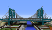
The Kings Highway Bridge is a suspension bridge that crosses the the New Bakersville Canal as well as north Coney Island, connecting Old Town to Coney Island carrying ![]() and four railroad tracks.
and four railroad tracks.
History
The Bridge officially opened to traffic on October 7th, 1910. It was the first suspension bridge to have been built in New Bakersville. Originally, the bridge would've spanned a large widening and extension of the New Bakersville Canal, which would've allowed more boat traffic to travel into the Midtown Area. Plans for this project, and bridge connecting Old Town to Bowery and Coney Island had existed since the 1860s. In 1904 following the Port Authority's formation, projects for a bridge and canal widening were proposed, and construction began on the bridge the same year. However, due to budget cuts, a lack of interest, and protests from shop owners in Bowery, the canal was never widened.
The bridge was constructed in an unusual method. A temporary bridge was built where the permanent bridge would be. Then, using large-scale, cheap scafolding, the temporary bridge was slowly be converted into the permanent bridge. This approach was chosen as the New Bakersville Canal wasn't a large enough obstacle to warrant more expensive methods of bridge construction. Construction on the bridge meant that a majority of transit service in the area beneath the bridge had to be suspended or reduced in service, affecting a major rail line and roads. This led the Port Authority to PATH (Port Authority Trans-Harbor), which could directly bypass the construction site beneath the bridge and travel between Coney Island and Midtown via the bridge.
Description
The bridge has four vehicle lanes on the upper level, split between two roadways carrying opposite directions of traffic. The lower level has two reversible vehicle lanes (for express service), four railroad tracks, a walkway and a bikeway. The bridge carries NBC-2, immediately off the highway junction in Old Town with the A230.
The North side of the bridge connects to a highway junction with the A230. Fourth Street runs immediately adjacent to the northern anchorage, with the New Bakersville Canal Main Line following to the south.
To the South of the canal, the bridge crosses over Bowery Street, the Broker Bridge, and First Street, respectively. The southern anchorage provides walking access to Canal Park and Revere Beach.
Railroad Tracks
Four railroad tracks are located on the lower deck of the bridge, two on each side of the roadway. The two tracks on the west side are to be used for a future railway line. The tracks on the east side are to be for the PATH Coney Island Shuttle..
Old Town Tunnel
| Old Town Tunnel | |
|---|---|
 | |
| Carries | 8 lanes of roadway |
| Locale | Old Town |
| Maintained By | Port Authority of New Bakersville |
| History | |
| Designer | Fred Rail |
| Builder | Fred Rail |
| Construction Start | 1890 |
| Construction End | 1892 |
| Opened | Janurary 6, 1893 |
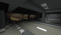
The Old Town Tunnel is a highway tunnel on the ![]() beneath Old Town.
beneath Old Town.
History
The Old Town Tunnel was originally a railroad tunnel between Old Town Junction and Union Freight Terminal. It allowed freight trains to travel beneath several housing zones without causing too much of a disruption. When the Union Freight Terminal was torn down in 1967, the tunnel became useless. Until the construction of the A230 in 1996, much of the former rail yard was used to store decommissioned locomotives.
Description
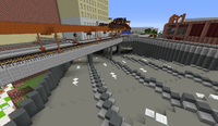
The tunnel consists mostly of arched brick paved in a straight line. Some areas are designed with simple steel beams, due to them previously being open trenches. A large section was cut open in 2000 for an interchange to NBC-2 from A230. A majority of the tunnel is separated into individual tunnels, housing two lanes within each segment. The arched portion crosses adjacently to Chandler Street, Lawrence Street, and Appleton Street.
The eastern end of the tunnel was built using a cut and cover method to support the structures on Benjamin Street. A portion of exit 7 is built into the tunnel.
The outer lanes provide local access to the city, well the four inner lanes bypass exits 6 and 7.
Midtown Tunnel
| Midtown | |
|---|---|
 | |
| Carries | 8 lanes of roadway |
| Locale | Midtown |
| Maintained By | Port Authority of New Bakersville |
| History | |
| Construction Start | 1995 |
| Construction End | 1996 |
| Opened | July 6, 1996 |
The Midtown Tunnel is a highway tunnel cut beneath Midtown of New Bakersville. It provides service to ![]()
![]()
History
The tunnel was built from a previously excavated tunnel for an abandoned City Hall Railroad Station beneath Market Place. The tunnel also had to cut through an abandoned subway tunnel as, between Fourth Street and Gallery Place stations on the Fourth Avenue and the Fifth Avenue subway lines.
Description
The tunnel is built using steel beams to suspend the tunnel ceiling. It ramps down to avoid a separate road tunnel on Fifth Avenue.
Train
PATH
Port Authority Trans-Harbor is a regional railroad company owned by the Port Authority but operated under Fred Rail. It serves as a commuter rail in the city.
Blue Line
The Blue Line, formerly known as the Union and Seaport Line serves New Bakersville between New Bakersville Union Station and World's Fair Station along the New Bakersville Canal. All stations are currently operational.
| PATH Blue Line | ||||||||||||||||||||||||||||||||||||||||||||||||||||||||||||||||||||||||||||||||||||||||||||||
|---|---|---|---|---|---|---|---|---|---|---|---|---|---|---|---|---|---|---|---|---|---|---|---|---|---|---|---|---|---|---|---|---|---|---|---|---|---|---|---|---|---|---|---|---|---|---|---|---|---|---|---|---|---|---|---|---|---|---|---|---|---|---|---|---|---|---|---|---|---|---|---|---|---|---|---|---|---|---|---|---|---|---|---|---|---|---|---|---|---|---|---|---|---|---|
|
| ||||||||||||||||||||||||||||||||||||||||||||||||||||||||||||||||||||||||||||||||||||||||||||||
| ||||||||||||||||||||||||||||||||||||||||||||||||||||||||||||||||||||||||||||||||||||||||||||||
Green Line
The Green Line is a planned shuttle to run between New Bakersville Union Station and Coney Island - Stillwell Avenue Station.