New Bakersville Canal
| New Bakersville Canal | |
|---|---|
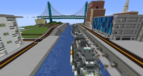
 A view of the canal going west. | |
| Specifications | |
| Length | 0.663 km (0.412 miles) |
| Maximum boat length | 61 m (200 ft 2 in) |
| Maximum boat beam | 15 m (49 ft 3 in) |
| Status | Open |
| Navigation authority | Port Authority of New Bakersville |
| History | |
| Former names | New Bakersville City Canal |
| Geography | |
| Start point | Monterey Lake (Flushing Bay) |
| End point | Downtown Arm (Grand Union Canal) |
The New Bakersville Canal is a canal across central New Bakersville City. It is both the widest and the shortest canal in the city.
Canal Description
New Bakersville Canal | |||||||||||||||||||||||||||||||||||||||||||||||||
|---|---|---|---|---|---|---|---|---|---|---|---|---|---|---|---|---|---|---|---|---|---|---|---|---|---|---|---|---|---|---|---|---|---|---|---|---|---|---|---|---|---|---|---|---|---|---|---|---|---|
| |||||||||||||||||||||||||||||||||||||||||||||||||
The New Bakersville Canal begins in Flushing Bay on the far east side of Monterey Lake north-northeast of EN12 New Bakersville - Brighton Beach station. The canal briefly travels north before turning east along Third Street. It then proceeds along the Third Street Docks until it turns south at Seventh Avenue briefly to the First Street Bridge, where it becomes the Downtown Arm of the Grand Union Canal. The canal maintains sea level its entire length. Unlike other canals in New Bakersville, the New Bakersville Canal has no towpaths. However, there are multiple streets and paths on embankments along the canal.
Service
Hummingbird Boat Lines routes 7, 17, 24, and 26 and WMB provide service to Third Street Docks along the north side of the canal.
- Hummingbird Boat Lines 7 Sunflower Line
- Service to MRT Marina, Railroad Isle, and Soiled Solitude
- Hummingbird Boat Lines 17 Brunia Line
- Service to Ilirea, Los Angeles, and Onemalu
- Hummingbird Boat Lines 24 Pansy Line
- Service to Bakersville, Kenthurst north, and Roke
- Hummingbird Boat Lines 26 Larkspur Line
- Service to Fort Yaxier, Gray Cloud, and Oparia
- WMB 06 Fred-ex
- Service to PMW City and Bakersville