Boston Underground
| Boston Underground | |
|---|---|
 | |
| Overview | |
| Locale | Boston , Ward 5 |
| Transit type | Rapid transit |
| Number of lines | 11 |
| Part of a series of articles on the |
| Boston Underground |
|---|
 |
|
Overview Stations Map |
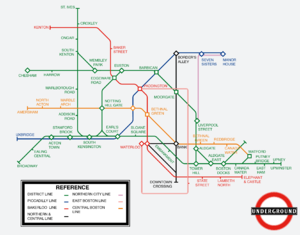
The Boston Underground (also known as the Tube) is a rapid transit system serving Boston.
History
Metropolitan and District Railway
The Metropolitan and District Railway was the first urban railway in the city of Boston. It was commissioned by Mayor Nathaniel Stephens in 1864 in order to reduce street congestion. At first, an elevated railway was considered, but was later rejected due to fears that construction over the street would lead to over-congestion.
When construction started in late 1864, the streets were led to over-congestion, due to poor engineering and the constant collapsing of buildings and streets nearby. Whenever the railway had to go beneath a street, both sides were trenched, long wooden platforms were shoved beneath the street, and then the ground below the wooden platform was slowly removed. However, because the supports were built directly into the ground that was to be excavated beneath the street, and the poor qualities of wet, cheap wood from rain in the autumn season, the streets would collapse. The same wood was used to retain walls in the trenches, and thus collapsed and caved in.
In January of 1865, Mayor Nathaniel Stephens filed a lawsuit against the construction firm he had hired. They were to either manage a way to keep water and snow out of the trenches, or use bricks of the highest quality in order to retain and maintain the integrity of the railway and all infrastructure surrounding it. The construction firm had lost more than half of their workers from walls and ceilings collapsing, and thus couldn't simply manually remove rain water or snow if they were to reach their deadline of 1868. They decided to opt in to use brick and mortar to build tunnels and trenches, which still stand strong today.
The first segment of the line opened between Aldgate and Chesham in March of 1868, and then a branch from St. Ives to Wapping in December of 1868 following the acquisition of the St. Ives and Wapping Railway. The segment between Aldgate and Broadway opened next in July of 1870, with a connection between Euston and South Kensington opening in September of the same year, and a branch to Kenton in November. The last main segments of the railway opened in April of 1875, to the east of Aldgate. This includes the Tower Gateway and Watford branches on the line to Upminster (Now known as Croydon). A temporary service to Waterloo opened in 1882 via the City Widened Lines and lasted through the acquisition from the Underground Electric Railways of Boston up until 1933.
Boston Electric Railway
The Boston Electric Railway was the second urban railway in Boston and the first to use deep-level tubes. A test tube was built between Waterloo and the city center (Eventually Bank tube station) from 1880 to 1882 beneath the Boston River, and ran for 3 years. This tube would eventually become part of the Waterloo and City line.
The first official line, the Northern line, ran from the city's border with Zaquar in an area known as Border's Alley to the Bank tube station. Due to it's contract with Fred Rail, right-handed equipment was used and remains used on this line. Construction began in 1884 and lasted until 1890. By the time the line was open, construction on the extensions had already begun. The extensions to Waterloo and Downtown Crossing opened in August 1982 with provisions for future extensions north and south.
The Boston Electric Railway's second line, the Bakerloo line, opened in 1900 and ran from Kilburn Park (Previously and currently known as Baker Street) to Elephant and Castle after 7 years of construction. At this time, it had used its own technology and the line wasn't running on the right side. The railway previously made a deal with the Metropolitan and District Railway in 1893 allowing shared infrastructure between Kilburn Park and Kenton as well as a future joint-company line so long as the Boston Electric Railway helped to electrify the Metropolitan and District Railway.
Piccadilly and Uxbridge Railway
The Piccadilly and Uxbridge Railway (later the Piccadilly line was a joint-railway company between the Boston Electric Railway and the Metropolitan and District Railway. Each company owned 50% of the railway, with frequent connections at stations on both railways. Construction began in 1895, fully opening 5 years later in 1900 at the same time as the Bakerloo line. The first segment opened in 1896 between Uxbridge and South Kensington. It helped traffic between Acton Town and Earl's Court, as it ran parallel to the Metropolitan and District Railway, but operated on its own tracks. The final segment ran to Manor House via Piccadilly Circus.
Central Boston Railway
The Central Boston Railway, later the Central line was the second deep-level tube system and the third urban railway company in Boston, forming in 1890 after the success of the Boston Electric Railway's Northern line. Service began in 1893 between it's own Notting Hill Gate and Bank stations, running through Central Boston. It was the main rival of the Metropolitan and District Railway and the Boston Electric Railway, often taking the same location and names of pre-existing or planned stations. An extension to Boston Docks opened in 1897 and another to Amersham opened in 1899.
Underground Electric Railways of Boston
The Underground Electric Railways of Boston formed as a merger of the Boston Electric Railway and the Metropolitan and District Railway in 1902. It purchased the Central Boston Railway, the East Boston Railway, and the Northern City Railway.
The East Boston Railway was a short railway that ran from Paddington to Waterloo via Stratford and was purchased as a full-time alternative to the City Widened Lines which ran a single train each hour, compared to three trains per hour. Passengers transferring also preferred to transfer from the same mezzanine they arrived at, compared to having to navigate through the system's labyrinth of tunnels.
The Northern City Railway was a short railway that ran from Liverpool Street station to Manor House. It had existed before the Northern and Piccadilly lines, but hadn't much use. Although it remained on the map until 1933, the UERB silently ended service around 1905.
1930s Rebranding
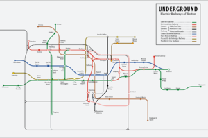
The 1930s saw a complete overhaul of the UERB, after the Boston Government threatened to seize control over it due to the company's slow demise into poor management. The Underground Electric Railways of Boston was shortened to the Boston Underground, with new branding similar to that of its current design. In 1933, a new map was released, replacing an outdated one from 1905. New routes and line extensions were explored, and the Boston Underground Company held a public contest to choose line colors, which would appear on the 1934 map.
Government Acquisition
In 1945, the Boston Government attempted to take control over the Boston Underground as well as several other privately owned transportation companies in order to "better manage the city's transportation networks". The city was managed by the Wehateanythingprivatelyownedunlessweownit Party, which wanted to take authoritative control over everything in Boston. They rammed the economy into the ground by taking control of local mints and printing absurd amounts of money, leading to over-inflation. The also made it illegal for transportation companies to charge fares, slowly driving them into bankruptcy. An act was passed known as the Transportation Seizeation Act in which the Boston Government automatically became owners of any bankrupt transportation companies. There was a revolution, which established an actual constitution to the City of Boston, and worked to reform the economy and the government. The government still had control over the transportation system, and had established the Boston Underground as a government entity by 1948 in order to keep the trains on time.
Under the re-established government's order, not much happened. This was most likely due to a bunch of government people who had never ridden a subway train or bus in their lives. Every now and then, an intern would propose a new map design, though the Boston Underground remained in limbo until 1960. The new city Mayor had ordered the Boston Underground to work on new lines in order to reduce street-level traffic. As he said in an interview, "I can't have these white and blue and pink and whichever collared idiots on my streets, stick them in their rat tube! I need my streets for my expensive cars and limo rides!". It took 8 years for the first of the new lines, the Victoria line, to come into existence, 8 years since the mayor who proposed the lines was in office. It took another 5 years just for the line to be complete, and it wasn't until 1979 for the first three stations of the Jubilee line to be opened. Some slight line and service adjustments cropped up every now and then, until Transport for Boston was formed in 2019 and took control of the Boston Underground.
Transport for Boston
In 2019, Transport for Boston was formed by the Boston Government in order to "better manage the city's transportation networks". The supposed function of Transport for Boston is to fix the stagnation and unreliability of the Boston Underground and other city transportation networks that endured from government control by pretending to be a private company despite being directly government controlled. Not much is expected to change regarding the Boston Underground well in control by Transport for Boston, other than a few renovations and a possible extension north, but it's impossible to tell the exact future, so who knows?
Infastructure
| Subsurface Lines on the Boston Underground | ||||||||||||||||||||||||||||||||||||||||||||||||||||||||||||||||||||||||||||||||||||||||||||||||||||||||||||||||||||||||||||||||||||||||||||||||||||||||||||||||||||||||||||||||||||||||||||||||||||||||||||||||||||||||||||||||||||||||||||||||||||||||||||||||||||||||||||||||||||||||||||||||||||||||||||||||||||||||||||||||||||||||||||||||||||||||||||||||||||||||||||||||||||||||||||||||||||||||||||||||||||||||||||||||||||||||||||||||||||||||||||||||||||||||||
|---|---|---|---|---|---|---|---|---|---|---|---|---|---|---|---|---|---|---|---|---|---|---|---|---|---|---|---|---|---|---|---|---|---|---|---|---|---|---|---|---|---|---|---|---|---|---|---|---|---|---|---|---|---|---|---|---|---|---|---|---|---|---|---|---|---|---|---|---|---|---|---|---|---|---|---|---|---|---|---|---|---|---|---|---|---|---|---|---|---|---|---|---|---|---|---|---|---|---|---|---|---|---|---|---|---|---|---|---|---|---|---|---|---|---|---|---|---|---|---|---|---|---|---|---|---|---|---|---|---|---|---|---|---|---|---|---|---|---|---|---|---|---|---|---|---|---|---|---|---|---|---|---|---|---|---|---|---|---|---|---|---|---|---|---|---|---|---|---|---|---|---|---|---|---|---|---|---|---|---|---|---|---|---|---|---|---|---|---|---|---|---|---|---|---|---|---|---|---|---|---|---|---|---|---|---|---|---|---|---|---|---|---|---|---|---|---|---|---|---|---|---|---|---|---|---|---|---|---|---|---|---|---|---|---|---|---|---|---|---|---|---|---|---|---|---|---|---|---|---|---|---|---|---|---|---|---|---|---|---|---|---|---|---|---|---|---|---|---|---|---|---|---|---|---|---|---|---|---|---|---|---|---|---|---|---|---|---|---|---|---|---|---|---|---|---|---|---|---|---|---|---|---|---|---|---|---|---|---|---|---|---|---|---|---|---|---|---|---|---|---|---|---|---|---|---|---|---|---|---|---|---|---|---|---|---|---|---|---|---|---|---|---|---|---|---|---|---|---|---|---|---|---|---|---|---|---|---|---|---|---|---|---|---|---|---|---|---|---|---|---|---|---|---|---|---|---|---|---|---|---|---|---|---|---|---|---|---|---|---|---|---|---|---|---|---|---|---|---|---|---|---|---|---|---|---|---|---|---|---|---|---|---|---|---|---|---|---|---|---|---|---|---|---|---|---|---|---|---|---|---|---|---|---|---|---|---|---|---|---|---|---|---|---|---|---|---|---|---|---|---|---|---|---|---|---|---|---|---|
| ||||||||||||||||||||||||||||||||||||||||||||||||||||||||||||||||||||||||||||||||||||||||||||||||||||||||||||||||||||||||||||||||||||||||||||||||||||||||||||||||||||||||||||||||||||||||||||||||||||||||||||||||||||||||||||||||||||||||||||||||||||||||||||||||||||||||||||||||||||||||||||||||||||||||||||||||||||||||||||||||||||||||||||||||||||||||||||||||||||||||||||||||||||||||||||||||||||||||||||||||||||||||||||||||||||||||||||||||||||||||||||||||||||||||||
The Boston Underground has a large variety of infrastructure based on many factors. There are 57 total stations.
Lines
There are 11 lines in total on the Boston Underground.
| Name | Map color |
Type | Termini | No. stations |
Depots | |
|---|---|---|---|---|---|---|
| Bakerloo line | style="background:#B36305
|
Deep Tube |
Kenton | Elephant & Castle | 9 | Kenton Waterloo |
| Central line | style="background:#E32017
|
Deep Tube |
Amersham | Watford | 11 | Acton Watford |
| Circle line | style="background:#FFD300
|
Sub surface |
Edgware Road clockwise via Moorgate and Aldgate |
Edgware Road anti-clockwise via Aldgate and Moorgate |
11 | Moorgate |
| District line | style="background:#00782A
|
Sub surface |
Broadway Kensington (Olympia) |
Edgware Road Upminster |
19 | Acton Croydon |
| Hammersmith & City line |
style="background:#F3A9BB
|
Sub surface |
South Kensington | Tower Gateway | 10 | Moorgate |
| Jubilee line | style="background:#A0A5A9
|
Deep Tube |
Stanmore | Canning Town | 9 | Waterloo Canning Town |
| Metropolitan line | style="background:#9B0056
|
Sub surface |
Chesham St Ives |
Wembley Park Aldgate |
11 | Moorgate |
| Northern line | style="background:#000000
|
Deep Tube |
Border's Alley | Waterloo Downtown Crossing |
6 | Waterloo |
| Piccadilly line | style="background:#003688
|
Deep Tube |
Manor House | Uxbridge South Ealing |
11 | Manor House Acton |
| Victoria line | style="background:#0098D4
|
Deep Tube |
Manor House | Sports Centre | 9 | Manor House |
| Waterloo & City line | style="background:#95CDBA
|
Deep Tube |
Bank | Waterloo | 2 | Waterloo |
- Note:The table lists existing, planned, and stations under construction.
Travelling
Ticket machines are provided in every station. Fare gates accept most transportation cards.


